Filter: Categories of Wisconsin Historical Images
Filter: FORMAT_TYPE of photographic print, b
Filter: Subject of bird's-eye views
Filter: Categories of Wisconsin Historical Images
Filter: FORMAT_TYPE of photographic print, b
Filter: Subject of bird's-eye views
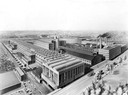
| Date: | 1910 |
|---|---|
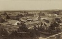
| Description: | Birds-eye view of International Harvester's Milwaukee Works located at 1714 West Bruce Street. The factory was originally owned by the Milwaukee Harvester ... |

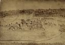
| Date: | 1867 |
|---|---|
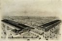
| Description: | Bird's-eye map of Green Bay and Fort Howard, Brown Co., depicts street names and street layouts, houses, trees, and the East River. A reference key at the ... |

| Date: | 1881 |
|---|---|
| Description: | Darlington's first settlers arrived by 1826, attracted by the lead mines of the area. Arrival of the railroad in 1856 stimulated growth, and in 1857 the co... |

| Date: | 1880 |
|---|---|
| Description: | Bird's-eye map over the Mississippi River of Fountain City. Paddle steamers and steamboats are on the river, and bluffs are in the background. |

| Date: | 1870 |
|---|---|
| Description: | Bird's-eye view of the city of Manitowoc with a population of 5,168 inhabitants as it appears in 1870, the year the village was granted a city charter by t... |

| Date: | 1868 |
|---|---|
| Description: | Bird's-eye map of Manitowoc, with four insets. Manitowoc County. |
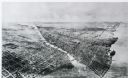
| Date: | 1911 |
|---|---|
| Description: | Black and white image, looking west from Lake Winnebago with Fox River flowing from top left corner to bottom right corner. Streets laid out with indicatio... |

| Date: | 1861 |
|---|---|
| Description: | Bird's-eye map of Fond du Lac, "drawn after nature," with a parade of soldiers marching down the street. |

| Date: | 1860 |
|---|---|
| Description: | Bird's-eye drawing of New Glarus. |
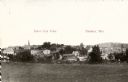
| Date: | 1911 |
|---|---|
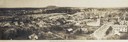
| Description: | Elevated panoramic view. Business district has a cluster of larger brick buildings at left and center, behind a sprinkling of houses. Very large building i... |
| Date: | 1907 |
|---|---|
| Description: | Caption reads: "Birdseye [sic] View of Cameron Wisconsin." Railroad cars are on railroad tracks between buildings, and houses and what may be the hi... |

| Date: | 1910 |
|---|---|
| Description: | Bird's-eye view. Caption reads: "Madison, Wis. and the Four Lake Region." |
| Date: | 1921 |
|---|---|
| Description: | Bird's-eye view of the Winther Motor and Truck Company factory and grounds. |

| Date: | 1915 |
|---|---|
| Description: | Elevated view of Janesville from the School House. Caption reads: "Bird's-eye View from School house, Janesville, Wis." |

| Date: | 1953 |
|---|---|
| Description: | Bird's-eye view of International Harvester's Phoenix Proving Ground. Opened in 1947, the proving ground was used by International Harvester through the 197... |
| Date: | 1912 |
|---|---|
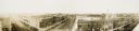
| Description: | Panoramic bird's-eye view. Identifiable businesses include: T.J. McNally Clothing & Shoes, M.J. Casey, The Winter Drug Store, Bank of New Richmond. |

| Date: | 1887 |
|---|---|
| Description: | A bird's-eye map of Menekaune, Menominee and Marinette. |

| Date: | 1920 |
|---|---|
| Description: | Bird-eye view of factory buildings at International Harvester's Akron Works. |
If you didn't find the material you searched for, our Library Reference Staff can help.
Call our reference desk at 608-264-6535 or email us at: