Filter: Categories of Wisconsin Historical Images
Filter: FORMAT_TYPE of photographic print, b
Filter: County of Sauk
Filter: Subject of botany
Filter: Categories of Wisconsin Historical Images
Filter: FORMAT_TYPE of photographic print, b
Filter: County of Sauk
Filter: Subject of botany
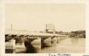
| Date: | 1925 |
|---|---|
| Description: | View across water along the right side of the Sauk City bridge, erected in 1922 to replace an old toll bridge. tree-covered hills are on the opposite shore... |

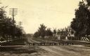
| Date: | 1909 |
|---|---|
| Description: | Wagon toll bridge. There is a building on the left, and a man is sitting on a bench on the right side of the road leading onto the bridge. |
| Date: | 1896 |
|---|---|
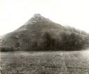
| Description: | View of Black Hawk Bluff, site of the Battle of Wisconsin Heights in the Black Hawk War. |

| Date: | 1909 |
|---|---|
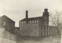
| Description: | Exterior view of a hop house built in about 1868 by H.J. Meyer. |

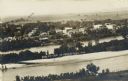
| Date: | 1895 |
|---|---|
| Description: | Elevated view of multiple homes and buildings. Hills are in the distance. |
| Date: | 1900 |
|---|---|
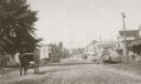
| Description: | View down unpaved Main Street, with a machine and repair shop on the right and multiple horse-drawn vehicles traveling along the road. |
| Date: | 1895 |
|---|---|
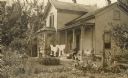
| Description: | Exterior view of the Kipp residence with laundry hanging in front and a man seated on the porch. |

| Date: | 1895 |
|---|---|
| Description: | Exterior view of the Kipp residence with a woman in the front yard reclining in a hammock. |
| Date: | 1930 |
|---|---|
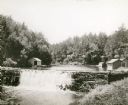
| Description: | View of the mill dam on Dell Creek that creates Mirror Lake in Mirror Lake State Park (although the photograph was taken before the site was designated as ... |
| Date: | 1850 |
|---|---|
| Description: | Buildings along Wisconsin River. |
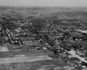
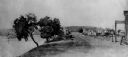
| Date: | |
|---|---|
| Description: | Elevated view of buildings lining the river in foreground, with farmland in background. Caption reads: "Bird's Eye View of Prairie Du Sac, Wis." |
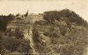
| Date: | 1907 |
|---|---|
| Description: | View of bluff taken from below. Caption reads: "Rattlesnake Bluff at Loddes Mill Sauk Co., Wis." |
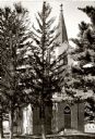
| Date: | 1935 |
|---|---|
| Description: | Salem Church of the Evanglical Association of North America. The original church was built in 1851 in the township of Honey Creek. This church is the third... |
| Date: | 1890 |
|---|---|
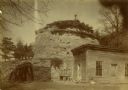
| Description: | Old Uncle Billy Johnson home at Governor Phillip's house, about six miles north of Prairie du Sac near highway 12. Portion of house, rock formation in back... |
| Date: | |
|---|---|
| Description: | View down unpaved road. Houses line the right side of street, telephone and power poles line left side. Caption reads: "Looking South on Park Ave. Pra.. Du... |
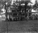
| Date: | 1906 |
|---|---|
| Description: | The land and house were donated to the village. The club house is still in use (1964) as a publicaly owned building for recreation and meetings. Image show... |
If you didn't find the material you searched for, our Library Reference Staff can help.
Call our reference desk at 608-264-6535 or email us at: