 Filter: Categories of Wisconsin Historical Images
Filter: FORMAT_TYPE of photocopy
Filter: Year of 1800-1899
Filter: Subject of cities and towns
Filter: Categories of Wisconsin Historical Images
Filter: FORMAT_TYPE of photocopy
Filter: Year of 1800-1899
Filter: Subject of cities and towns

| Date: | 1886 |
|---|---|
| Description: | Detail of map including plans of the National Soldiers' home. |
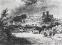
| Date: | 1810 |
|---|---|
| Description: | View of the city of Lincoln, England. Photocopy after an engraving by B.G. Topham. |
| Date: | 1878 |
|---|---|
| Description: | This map includes business directories, statistical table, distance table, list of county officers, and illustrated views of residential and commercial pro... |

| Date: | 1836 |
|---|---|
| Description: | This map shows land parcels, streets, the Fond du Lac River, Lake Winnebaygo (Winnebago), and blocks. Certification is on the left hand corner. The back of... |

| Date: | 1835 |
|---|---|
| Description: | Map shows the Fox River, lot and block numbers, private claims, streets, a public squares, a manual labour school, and Fort Howard. An inset map shows a pl... |
If you didn't find the material you searched for, our Library Reference Staff can help.
Call our reference desk at 608-264-6535 or email us at: