Filter: Categories of Wisconsin Historical Images
Filter: FORMAT_TYPE of photocopy
Filter: Subject of transportation
Filter: Categories of Wisconsin Historical Images
Filter: FORMAT_TYPE of photocopy
Filter: Subject of transportation

| Date: | 1835 |
|---|---|
| Description: | Map shows the Fox River, lot and block numbers, private claims, streets, a public squares, a manual labour school, and Fort Howard. An inset map shows a pl... |
| Date: | 1900 |
|---|---|
| Description: | Plat map showing a paper city located on the Wisconsin River. The map includes a public square, street names, and a note written by Francis Headman. |

| Date: | 1904 |
|---|---|
| Description: | Map showing lots, additions, and wards within the city limits, as well as some landownership. The streets are labeled, as is Lake Winnebago, rivers, railro... |

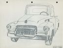
| Date: | 01 17 1939 |
|---|---|
| Description: | Three-quarter view from front right of D-Line truck parked in the snow outdoors. A spare tire is mounted on the outside of the open bed just behind the pas... |

| Date: | 1900 |
|---|---|
| Description: | Map showing a paper city on the shore of Lake Apuckwa (Lake Puckaway) in Marquette or Green Lake County. The map includes certifications signed by John V. ... |

| Date: | 1900 |
|---|---|
| Description: | Map showing a paper city located on the shore of Green Bay and south shore of the Fox River. The site is now part of Oshkosh. |

| Date: | 1900 |
|---|---|
| Description: | Map showing city wards, streets, block and lot numbers, additions, selected buildings, Lake Winnebago, the Fox River, and railroads as of 1895. The lower m... |

| Date: | 1947 |
|---|---|
| Description: | Map showing plats, streets, and the public square. The bottom margin of the map includes registration and certifications. |

| Date: | 1947 |
|---|---|
| Description: | This photocopy of a hand-drawn map shows streets, a public square, lots, and extensive registrations and certifications. |

| Date: | 1900 |
|---|---|
| Description: | This photocopy map shows blocks, lots, subdivisions, city wards, buildings, some landownership, and the Mississippi River. The map margins include business... |

| Date: | 1900 |
|---|---|
| Description: | This photocopy plat map of Pauquette, now Poynette, shows streets and lot numbers. |

| Date: | 1921 |
|---|---|
| Description: | This map shows selected streets, public buildings, churches, schools, businesses, warehouses, the harbor, the Root River, and Lake Michigan. The map includ... |
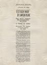
| Date: | 08 23 1919 |
|---|---|
| Description: | Newspaper article describing the test flight of Alfred Lawson's first transcontinental airplane. This article was copied and framed in a scrapbook related ... |
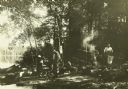
| Date: | 1911 |
|---|---|
| Description: | The Gang at their camp in a shady spot by Burntside Lake. The canoes are in the water on the left. |

| Date: | |
|---|---|
| Description: | Entrance into Berlin of the first battle trophies on Sedantage (anniversary of the Battle of Sedan). The column is being led by Colonel Jakobi. |

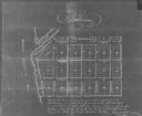
| Date: | 1906 |
|---|---|
| Description: | A diagram of Township No 37 Range No 8 in Sawyer County. |
| Date: | |
|---|---|
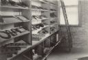
| Description: | Interior view of display of tools and other products arranged on shelves. The shelves are tilted down to display the parts, which are held in place by pins... |
| Date: | |
|---|---|
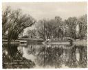
| Description: | A holiday card featuring Lake Dunmovin on the Zerk estate. The mansion is in the background on the left. On the opposite shoreline on the right is an arche... |
If you didn't find the material you searched for, our Library Reference Staff can help.
Call our reference desk at 608-264-6535 or email us at: