Filter: Categories of Wisconsin Historical Images
Filter: FORMAT_TYPE of photocopy
Filter: Subject of lakes
Filter: Categories of Wisconsin Historical Images
Filter: FORMAT_TYPE of photocopy
Filter: Subject of lakes

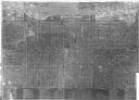
| Date: | 1925 |
|---|---|
| Description: | This map shows the public schools and their school districts. The bottom of the map reads:" Old buildings and sites in red. New buildings and sites in blac... |
| Date: | 1878 |
|---|---|
| Description: | This map includes business directories, statistical table, distance table, list of county officers, and illustrated views of residential and commercial pro... |

| Date: | 1836 |
|---|---|
| Description: | This map shows land parcels, streets, the Fond du Lac River, Lake Winnebaygo (Winnebago), and blocks. Certification is on the left hand corner. The back of... |

| Date: | 1904 |
|---|---|
| Description: | Map showing lots, additions, and wards within the city limits, as well as some landownership. The streets are labeled, as is Lake Winnebago, rivers, railro... |

| Date: | 1900 |
|---|---|
| Description: | Map showing a paper city on the shore of Lake Apuckwa (Lake Puckaway) in Marquette or Green Lake County. The map includes certifications signed by John V. ... |

| Date: | 1900 |
|---|---|
| Description: | This photocopy map shows landownership and mills in T35N, R17W as it appeared in 1885. Rice Lake, Little Balsam Lake, and Half Moon Lake are labeled. |

| Date: | 1900 |
|---|---|
| Description: | Map showing city wards, streets, block and lot numbers, additions, selected buildings, Lake Winnebago, the Fox River, and railroads as of 1895. The lower m... |
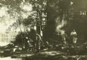
| Date: | 1911 |
|---|---|
| Description: | The Gang at their camp in a shady spot by Burntside Lake. The canoes are in the water on the left. |

| Date: | 1906 |
|---|---|
| Description: | A diagram of Township No 37 Range No 8 in Sawyer County. |
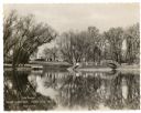
| Date: | |
|---|---|
| Description: | A holiday card featuring Lake Dunmovin on the Zerk estate. The mansion is in the background on the left. On the opposite shoreline on the right is an arche... |
If you didn't find the material you searched for, our Library Reference Staff can help.
Call our reference desk at 608-264-6535 or email us at: