Filter: Categories of Wisconsin Historical Images
Filter: FORMAT_TYPE of photocopy
Filter: Subject of human settlements
Filter: Categories of Wisconsin Historical Images
Filter: FORMAT_TYPE of photocopy
Filter: Subject of human settlements
| Date: | 1900 |
|---|---|
| Description: | Plat map showing a paper city located on the Wisconsin River. The map includes a public square, street names, and a note written by Francis Headman. |

| Date: | 1904 |
|---|---|
| Description: | Map showing lots, additions, and wards within the city limits, as well as some landownership. The streets are labeled, as is Lake Winnebago, rivers, railro... |

| Date: | 1900 |
|---|---|
| Description: | Map showing a paper city on the shore of Lake Apuckwa (Lake Puckaway) in Marquette or Green Lake County. The map includes certifications signed by John V. ... |

| Date: | 1900 |
|---|---|
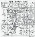
| Description: | This photocopy map shows landownership and mills in T35N, R17W as it appeared in 1885. Rice Lake, Little Balsam Lake, and Half Moon Lake are labeled. |

| Date: | 1900 |
|---|---|
| Description: | Map showing a paper city located on the shore of Green Bay and south shore of the Fox River. The site is now part of Oshkosh. |

| Date: | 1900 |
|---|---|
| Description: | Map showing city wards, streets, block and lot numbers, additions, selected buildings, Lake Winnebago, the Fox River, and railroads as of 1895. The lower m... |

| Date: | 1947 |
|---|---|
| Description: | Map showing plats, streets, and the public square. The bottom margin of the map includes registration and certifications. |

| Date: | 1947 |
|---|---|
| Description: | This photocopy of a hand-drawn map shows streets, a public square, lots, and extensive registrations and certifications. |

| Date: | 1900 |
|---|---|
| Description: | This photocopy map shows marshes, woods, buildings, and selected features including islands, mounds, old Fort Crawford, and "new site for a fort in questio... |
| Date: | 1930 |
|---|---|
| Description: | This photocopy map includes cross section of buildings. |

| Date: | 1942 |
|---|---|
| Description: | This photocopy plat map represents the relative position and size of the sloughs and islands in the Mississippi River, opposite Prairie du Chien. |

| Date: | 1900 |
|---|---|
| Description: | This photocopy map shows blocks, lots, subdivisions, city wards, buildings, some landownership, and the Mississippi River. The map margins include business... |

| Date: | 1900 |
|---|---|
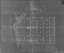
| Description: | This photocopy plat map of Pauquette, now Poynette, shows streets and lot numbers. |

| Date: | 1921 |
|---|---|
| Description: | This map shows selected streets, public buildings, churches, schools, businesses, warehouses, the harbor, the Root River, and Lake Michigan. The map includ... |

| Date: | |
|---|---|
| Description: | Entrance into Berlin of the first battle trophies on Sedantage (anniversary of the Battle of Sedan). The column is being led by Colonel Jakobi. |

| Date: | 07 03 1910 |
|---|---|
| Description: | Front page of the "Milwaukee Free Press Sunday Magazine." The article is titled: "The Only Real Labor Troubles in Milwaukee's History. Exciting Times Durin... |

| Date: | 1906 |
|---|---|
| Description: | A diagram of Township No 37 Range No 8 in Sawyer County. |

| Date: | 1906 |
|---|---|
| Description: | A list of owners of land in Township No 37 Range No 8 in Sawyer County. |
| Date: | 07 1936 |
|---|---|
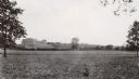
| Description: | View across field towards the Forest Products Laboratory. |
If you didn't find the material you searched for, our Library Reference Staff can help.
Call our reference desk at 608-264-6535 or email us at: