Filter: Categories of Wisconsin Historical Images
Filter: FORMAT_TYPE of photocopy
Filter: Subject of human settlements
Filter: Subject of rivers
Filter: Categories of Wisconsin Historical Images
Filter: FORMAT_TYPE of photocopy
Filter: Subject of human settlements
Filter: Subject of rivers
| Date: | 1955 |
|---|---|
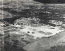
| Description: | Aerial view of Valley Fair Mall, with a residential area beyond it on both sides of a river, all surrounded by trees and farmland. |

| Date: | 1900 |
|---|---|
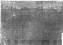
| Description: | This map shows the additions made in January 1855, as well as houses, streets, Catfish Creek, and the Milwaukee and Mississippi Rail Road and Depot. It als... |
| Date: | 1911 |
|---|---|
| Description: | This map includes references to reservoirs, industrial sites, and drainage basins. |
| Date: | 1878 |
|---|---|
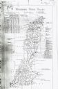
| Description: | This map includes business directories, statistical table, distance table, list of county officers, and illustrated views of residential and commercial pro... |

| Date: | 1836 |
|---|---|
| Description: | This map shows land parcels, streets, the Fond du Lac River, Lake Winnebaygo (Winnebago), and blocks. Certification is on the left hand corner. The back of... |
| Date: | 1913 |
|---|---|
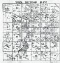
| Description: | This map shows landownership, rural mail routes, rural buildings, railroads, U.S. national highways, state trunk highways, county trunk highways, township... |

| Date: | 1835 |
|---|---|
| Description: | Map shows the Fox River, lot and block numbers, private claims, streets, a public squares, a manual labour school, and Fort Howard. An inset map shows a pl... |
| Date: | 1900 |
|---|---|
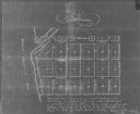
| Description: | Plat map showing a paper city located on the Wisconsin River. The map includes a public square, street names, and a note written by Francis Headman. |

| Date: | 1904 |
|---|---|
| Description: | Map showing lots, additions, and wards within the city limits, as well as some landownership. The streets are labeled, as is Lake Winnebago, rivers, railro... |

| Date: | 1900 |
|---|---|
| Description: | Map showing a paper city located on the shore of Green Bay and south shore of the Fox River. The site is now part of Oshkosh. |

| Date: | 1900 |
|---|---|
| Description: | Map showing city wards, streets, block and lot numbers, additions, selected buildings, Lake Winnebago, the Fox River, and railroads as of 1895. The lower m... |

| Date: | 1900 |
|---|---|
| Description: | This photocopy map shows marshes, woods, buildings, and selected features including islands, mounds, old Fort Crawford, and "new site for a fort in questio... |

| Date: | 1921 |
|---|---|
| Description: | This map shows selected streets, public buildings, churches, schools, businesses, warehouses, the harbor, the Root River, and Lake Michigan. The map includ... |
If you didn't find the material you searched for, our Library Reference Staff can help.
Call our reference desk at 608-264-6535 or email us at: