 Filter: Categories of Wisconsin Historical Images
Filter: FORMAT_TYPE of photocopy
Filter: Subject of buildings
Filter: Categories of Wisconsin Historical Images
Filter: FORMAT_TYPE of photocopy
Filter: Subject of buildings
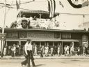
| Date: | 1927 |
|---|---|
| Description: | Crowds walking past the Horticulture Building at the Wiconsin State Fair. In a pavilion above the building the Aluminum Goose Manufacturing Co. Band of Ma... |
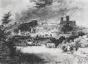
| Date: | 1810 |
|---|---|
| Description: | View of the city of Lincoln, England. Photocopy after an engraving by B.G. Topham. |
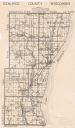
| Date: | 1913 |
|---|---|
| Description: | This map shows landownership, rural mail routes, rural buildings, railroads, U.S. national highways, state trunk highways, county trunk highways, township... |

| Date: | 1900 |
|---|---|
| Description: | This photocopy map shows marshes, woods, buildings, and selected features including islands, mounds, old Fort Crawford, and "new site for a fort in questio... |
| Date: | 1930 |
|---|---|
| Description: | This photocopy map includes cross section of buildings. |

| Date: | |
|---|---|
| Description: | Entrance into Berlin of the first battle trophies on Sedantage (anniversary of the Battle of Sedan). The column is being led by Colonel Jakobi. |
If you didn't find the material you searched for, our Library Reference Staff can help.
Call our reference desk at 608-264-6535 or email us at: