Filter: Categories of Wisconsin Historical Images
Filter: FORMAT_TYPE of photocopy
Filter: Creator Name of Unknown
Filter: Subject of human settlements
Filter: Categories of Wisconsin Historical Images
Filter: FORMAT_TYPE of photocopy
Filter: Creator Name of Unknown
Filter: Subject of human settlements
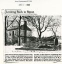
| Date: | 03 24 1983 |
|---|---|
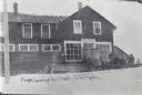
| Description: | Newspaper clipping showing the demolishing of the Long House. The man on the right is believed to be M.V. Adkins, son of Chester Adkins, the last survivor ... |
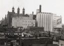
| Date: | 1940 |
|---|---|
| Description: | There is a sign painted on a building at right that reads "Schlitz". In the bottom right are railroad cars. |
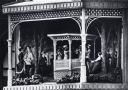
| Date: | 1970 |
|---|---|
| Description: | Close-up detail of scene of historic Wisconsin in a hexagonal structure on a pedestal beneath the clock. The scene depicts an outdoor band concert in Milwa... |
| Date: | |
|---|---|
| Description: | A stagecoach full of people is outside the post office on snow-covered ground, waiting to leave town. Text on image reads: "Stage, Leaving Arbor Vitae, Wis... |
| Date: | 1810 |
|---|---|
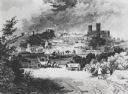
| Description: | View of the city of Lincoln, England. Photocopy after an engraving by B.G. Topham. |

| Date: | 1925 |
|---|---|
| Description: | This map shows the public schools and their school districts. The bottom of the map reads:" Old buildings and sites in red. New buildings and sites in blac... |

| Date: | 1900 |
|---|---|
| Description: | This set of photocopy bird's-eye-view maps include one view looking west from the top of Wisconsin River bluffs; and a second view looking east towards La ... |

| Date: | 1900 |
|---|---|
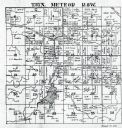
| Description: | This photocopy map shows landownership and mills in T35N, R17W as it appeared in 1885. Rice Lake, Little Balsam Lake, and Half Moon Lake are labeled. |

| Date: | 1900 |
|---|---|
| Description: | This photocopy map shows marshes, woods, buildings, and selected features including islands, mounds, old Fort Crawford, and "new site for a fort in questio... |
| Date: | 1930 |
|---|---|
| Description: | This photocopy map includes cross section of buildings. |

| Date: | 1900 |
|---|---|
| Description: | This photocopy plat map of Pauquette, now Poynette, shows streets and lot numbers. |

| Date: | 07 03 1910 |
|---|---|
| Description: | Front page of the "Milwaukee Free Press Sunday Magazine." The article is titled: "The Only Real Labor Troubles in Milwaukee's History. Exciting Times Durin... |

| Date: | 1906 |
|---|---|
| Description: | A diagram of Township No 37 Range No 8 in Sawyer County. |

| Date: | 1906 |
|---|---|
| Description: | A list of owners of land in Township No 37 Range No 8 in Sawyer County. |
| Date: | 07 1936 |
|---|---|
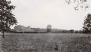
| Description: | View across field towards the Forest Products Laboratory. |
If you didn't find the material you searched for, our Library Reference Staff can help.
Call our reference desk at 608-264-6535 or email us at: