Filter: Categories of Wisconsin Historical Images
Filter: FORMAT_TYPE of photocopy
Filter: Creator Name of Unknown
Filter: Subject of cities and towns
Filter: Subject of land
Filter: Categories of Wisconsin Historical Images
Filter: FORMAT_TYPE of photocopy
Filter: Creator Name of Unknown
Filter: Subject of cities and towns
Filter: Subject of land
| Date: | 1810 |
|---|---|
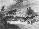
| Description: | View of the city of Lincoln, England. Photocopy after an engraving by B.G. Topham. |

| Date: | 1900 |
|---|---|
| Description: | This set of photocopy bird's-eye-view maps include one view looking west from the top of Wisconsin River bluffs; and a second view looking east towards La ... |

| Date: | 1900 |
|---|---|
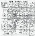
| Description: | This photocopy map shows landownership and mills in T35N, R17W as it appeared in 1885. Rice Lake, Little Balsam Lake, and Half Moon Lake are labeled. |

| Date: | 1900 |
|---|---|
| Description: | This photocopy map shows marshes, woods, buildings, and selected features including islands, mounds, old Fort Crawford, and "new site for a fort in questio... |

| Date: | 1906 |
|---|---|
| Description: | A diagram of Township No 37 Range No 8 in Sawyer County. |

| Date: | 1906 |
|---|---|
| Description: | A list of owners of land in Township No 37 Range No 8 in Sawyer County. |
If you didn't find the material you searched for, our Library Reference Staff can help.
Call our reference desk at 608-264-6535 or email us at: