 Filter: Categories of Wisconsin Historical Images
Filter: FORMAT_TYPE of negative, original
Filter: Subject of aerial photographs
Filter: Categories of Wisconsin Historical Images
Filter: FORMAT_TYPE of negative, original
Filter: Subject of aerial photographs
| Date: | 12 02 1970 |
|---|---|
| Description: | An aerial view of East Towne Shopping Center (now East Towne Mall) looking southeast across East Washington Avenue. |

| Date: | 08 28 1970 |
|---|---|
| Description: | An aerial view of West Towne Shopping Center (now West Towne Mall) at Mineral Point and Gammon Roads. |
| Date: | 1953 |
|---|---|
| Description: | Aerial view of Indianapolis Works, an International Harvester engine factory. |

| Date: | 1956 |
|---|---|
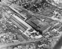
| Description: | Aerial view of the Chicago, Milwaukee, and St. Paul Railroad station, roundhouse, and yard at the intersection of West Washington Avenue (across lower left... |

| Date: | 1958 |
|---|---|
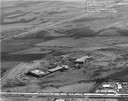
| Description: | Aerial view of Craig Avenue and Crestwood Avenue. |
| Date: | 1958 |
|---|---|
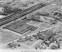
| Description: | Aerial photograph showing the J.S. Timlin Lumber Company, 2702 University Avenue, as well as Doctors Park, the Veterans Hospital, and the First Unitarian S... |

| Date: | 1950 |
|---|---|
| Description: | Aerial view of the Frank Lloyd-Wright-dsigned Unitarian Church under construction and the Veteran's Administration Hospital, also under construction, to th... |
| Date: | 1911 |
|---|---|
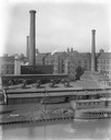
| Description: | International Harvester's McCormick Works on the river with railroad tracks and a cargo dock. The factory was owned by the McCormick Harvesting Machine Com... |
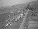
| Date: | 1954 |
|---|---|
| Description: | An aerial view of the air show at Tri-County Airport to celebrate the re-opening of the field under local management. Because of its location at the inters... |
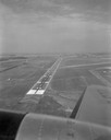
| Date: | 1954 |
|---|---|
| Description: | Aerial view of a new landing strip at Truax Field as photographed from a low-flying airplane. |
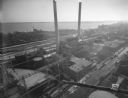
| Date: | 12 14 1931 |
|---|---|
| Description: | Aerial view of Madison industrial district taken from the top of the Madison Gas and Electric Co. gas tank looking south west down the 600 and 700 blocks o... |
| Date: | 04 09 1931 |
|---|---|
| Description: | Aerial view of Lake Delton airport. |

| Date: | 08 20 1930 |
|---|---|
| Description: | Aerial view of the Madison skyline from University of Wisconsin Field House, overlooking the Wisconsin State Capitol and, in the foreground, Gateway Lumber... |
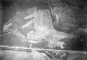
| Date: | 08 1929 |
|---|---|
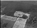
| Description: | Aerial view of the Dane County Tuberculosis Sanitorium under construction, at 1202 Northport Drive. J.P. Cullen, Contractor. |
| Date: | 1923 |
|---|---|
| Description: | Aerial view of the University of Wisconsin campus shows from west to east the Agricultural Hall, Observatory Hall and the Wisconsin Historical Society with... |

| Date: | 1923 |
|---|---|
| Description: | Aerial view of the Wisconsin Historical Society, Science Hall, and Bascom Hall on Bascom Hill on the University of Wisconsin-Madison campus. Lake Mendota i... |
| Date: | 10 18 1945 |
|---|---|
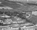
| Description: | Madison Ray-O-Vac plant, 2313-25 Winnebago Street. |

| Date: | 1955 |
|---|---|
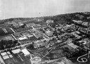
| Description: | Aerial view of town, with the Baraboo River. |

| Date: | 1945 |
|---|---|
| Description: | Aerial view of the "powder storage area" of the Badger Ordnance Plant. |
If you didn't find the material you searched for, our Library Reference Staff can help.
Call our reference desk at 608-264-6535 or email us at:
