 Filter: Categories of Wisconsin Historical Images
Filter: FORMAT_TYPE of negative, b/w copy
Filter: Subject of landforms
Filter: Categories of Wisconsin Historical Images
Filter: FORMAT_TYPE of negative, b/w copy
Filter: Subject of landforms

| Date: | 1874 |
|---|---|
| Description: | Bird's-eye map of Chippewa Falls. |

| Date: | 12 21 1882 |
|---|---|
| Description: | Bird's-eye map of Kaukauna, from the Appleton Post Annual Review. |

| Date: | 1892 |
|---|---|
| Description: | Bird's-eye map of Princeton, with an inset of the Residence of F.T. Yahr. Fox River loops to left of center, with one bridge; thirty-six businesses, reside... |

| Date: | 02 26 1887 |
|---|---|
| Description: | Bird's-eye map of Ashland, and the Apostle Islands in Lake Superior. Caption reads: "Ashland and the Apostle Islands." |

| Date: | 1928 |
|---|---|
| Description: | Aerial view of Madison looking southeast over the isthmus, showing the Four Lakes Country. Visible at the bottom is the Lake Mendota shoreline. At center, ... |
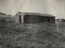
| Date: | 1917 |
|---|---|
| Description: | Original caption reads: "Union Pacific Special Trip: Oldest sod house in Platte Valley, 1886, H.W. Roberts." |
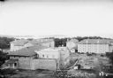
| Date: | 1925 |
|---|---|
| Description: | Elevated view of dormitories nearing construction completion on the University of Wisconsin-Madison campus. Adams, Van Hise and Tripp Halls are in the fore... |
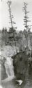
| Date: | 1930 |
|---|---|
| Description: | An elevated view of Brownstone Falls. Two tall pines are growing at the top edge of a rock to the right of the falls. |
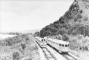
| Date: | 1935 |
|---|---|
| Description: | Two streamlined style, stainless steel clad passenger trains meet on the tracks at the base of a bluff along the Mississippi River near La Crosse. A sign ... |
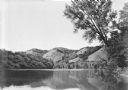
| Date: | 1935 |
|---|---|
| Description: | Four bluffs are reflected in the back waters of the Mississippi River. A large tree on the right frames the view. |

| Date: | 1935 |
|---|---|
| Description: | Slightly elevated view of the Eau Claire River flowing between block-like rock formations downstream from a stone bridge in the Dells of the Eau Claire Cou... |
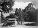
| Date: | 1934 |
|---|---|
| Description: | View looking up towards a log cabin near the base of a tall rock outcropping. |
If you didn't find the material you searched for, our Library Reference Staff can help.
Call our reference desk at 608-264-6535 or email us at: