Filter: Categories of Wisconsin Historical Images
Filter: FORMAT_TYPE of negative, b/w copy
Filter: Subject of human settlements
Filter: Year of 1800-1899
Filter: Categories of Wisconsin Historical Images
Filter: FORMAT_TYPE of negative, b/w copy
Filter: Subject of human settlements
Filter: Year of 1800-1899
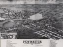
| Date: | 1882 |
|---|---|
| Description: | Bird's-eye map of Poynette, with one vignette. |

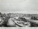
| Date: | 1850 |
|---|---|
| Description: | Painting depicting Chippewa Falls and the first sawmill on the Chippewa River, built by Jean Brunet. The residence of H.S. Allen, one of the owners of the... |
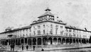
| Date: | 1888 |
|---|---|
| Description: | View of the Chequamegon Hotel, built by the Wisconsin Central railroad interests and opened in 1877. It faced the bay and had a long series of steps leadin... |
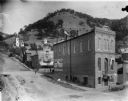
| Date: | 1895 |
|---|---|
| Description: | View looking east on Liberty Street from Shore Drive. In the foregound is the F. Bohri & Son Clothing store, and behind it is a store selling "Drugs, Medic... |
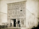
| Date: | 1890 |
|---|---|
| Description: | Three men posing with a McCormick mower and binder in front of M. Sheehan's McCormick Harvesting Machine Company dealership. A note on the back of the prin... |
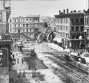
| Date: | 1870 |
|---|---|
| Description: | Buildings along Wisconsin Avenue lining a wide dirt road. |

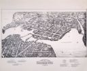
| Date: | 1874 |
|---|---|
| Description: | Bird's-eye map of Chippewa Falls. |

| Date: | 12 21 1882 |
|---|---|
| Description: | Bird's-eye map of Kaukauna, from the Appleton Post Annual Review. |

| Date: | 1892 |
|---|---|
| Description: | Bird's-eye map of Princeton, with an inset of the Residence of F.T. Yahr. Fox River loops to left of center, with one bridge; thirty-six businesses, reside... |

| Date: | 1875 |
|---|---|
| Description: | Bird's-eye map after a fire destroyed a large area of the town. In memory of the Great Conflagration on April 28th, 1875. Taken from the North-Side. |

| Date: | 1893 |
|---|---|
| Description: | Bird's-eye map of Sturgeon Bay, looking Northeast. Area bordered by Church Street in top left corner, leather & Smith Bridge in bottom left corner, Lawrenc... |

| Date: | 1880 |
|---|---|
| Description: | Bird's-eye map of Sturgeon Bay. County Seat of Door County. |

| Date: | 1881 |
|---|---|
| Description: | Bird's-eye view of Appleton. |

| Date: | 02 26 1887 |
|---|---|
| Description: | Bird's-eye map of Ashland, and the Apostle Islands in Lake Superior. Caption reads: "Ashland and the Apostle Islands." |

| Date: | 1857 |
|---|---|
| Description: | From Judge Smith Addition, 5th Ward, looking north, toward the city. Drawing is an elevated view of field and plank fence in foreground, road to the left a... |
If you didn't find the material you searched for, our Library Reference Staff can help.
Call our reference desk at 608-264-6535 or email us at: