 Filter: Categories of Wisconsin Historical Images
Filter: FORMAT_TYPE of manuscript
Filter: Subject of research
Filter: Categories of Wisconsin Historical Images
Filter: FORMAT_TYPE of manuscript
Filter: Subject of research
| Date: | |
|---|---|
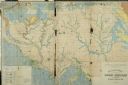
| Description: | Geological Map of the lead regions in Wisconsin, Illinois and Iowa. |
| Date: | 11 04 1921 |
|---|---|
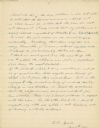
| Description: | The last, signed page of an 11-page manuscript titled "The Platforms at Trempeleau." |

| Date: | 01 13 1937 |
|---|---|
| Description: | Sketch map of Township 7 North, Range 9 East, created for the Land Economic Inventory (Bordner Survey). The map shows Picnic Point and the Lake Mendota sho... |
If you didn't find the material you searched for, our Library Reference Staff can help.
Call our reference desk at 608-264-6535 or email us at: