 Filter: Categories of Wisconsin Historical Images
Filter: FORMAT_TYPE of manuscript
Filter: Subject of land
Filter: Categories of Wisconsin Historical Images
Filter: FORMAT_TYPE of manuscript
Filter: Subject of land

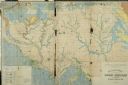
| Date: | 1848 |
|---|---|
| Description: | In 1849, northern Wisconsin was composed of huge sectional regions such as Chippewa, Portage, Brown and Crawford, whereas southern Wisconsin was constitute... |
| Date: | |
|---|---|
| Description: | Plat map of Mammoth Cave. A note on the map reads: "Mrs. Campbell conjectures that this is a saltpeter cave in Green River, Kentucky. The mummy found in it... |

| Date: | 1804 |
|---|---|
| Description: | A map of Lewis and Clark's Track across the western portion of North America from the Mississippi River to the Pacific Ocean by order of the Executive of t... |
| Date: | |
|---|---|
| Description: | Geological Map of the lead regions in Wisconsin, Illinois and Iowa. |
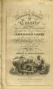
| Date: | 1820 |
|---|---|
| Description: | Narrative Journal of Travels from Detroit Northwest through the Great chain of American Lakes to the sources of the Mississippi River in the year 1820. Ill... |
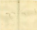
| Date: | |
|---|---|
| Description: | Hand-drawn map including the Clinch River and Clinch mountain range. The Clinch River rises in Southwest Virginia near Tazewell, VA and flows southwest thr... |
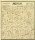
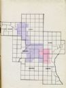
| Date: | 1873 |
|---|---|
| Description: | Columbia County Atlas Arlington Township 10 North Range 9 East. |
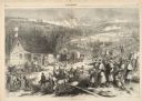
| Date: | 12 17 1862 |
|---|---|
| Description: | Illustration depicting a battle. In the foreground injured soldiers are gathered on and around the porch and yard of a house. In the background are columns... |

| Date: | 1909 |
|---|---|
| Description: | Map of Sawyer County with an advertisement for land sales through Fuley & Quail of Hayward, Wisconsin. There is a small inset map of railroads accessible i... |
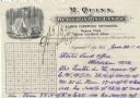
| Date: | |
|---|---|
| Description: | Letterhead of M. Quinn, "Dealer in Pine Lands," with two men in front of a tent at a campsite, one of whom is cooking over a campfire and the other is sitt... |
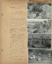
| Date: | 07 22 1941 |
|---|---|
| Description: | Scrapbook page of trip highlights from a bike hosteling trip to Pine Bluff (Dane County), Sauk City (Sauk County), and Okee (Columbia County), sponsored by... |
| Date: | 1935 |
|---|---|
| Description: | Map of a portion of Central Wisconsin with areas zoned for reforestation. The area is divided into two sites which are shaded in purple and red. |

| Date: | 1935 |
|---|---|
| Description: | Map of Juneau County showing area zoned for reforestation shaded in red. |

| Date: | 1977 |
|---|---|
| Description: | Cover of the 1977 International Scout Terra sales brochure featuring a man driving a red and white Scout over a sand dune. Cover reads: "1977 International... |

| Date: | 1977 |
|---|---|
| Description: | Cover of a sales brochure for the International Scout. The cover features a man driving a red, black, and tan Scout which is airborne over a sand dune. Cov... |

| Date: | 1977 |
|---|---|
| Description: | Cover of the 1977 International Scout II sales brochure featuring a gold and cream Scout being drive off-road on rough terrain. The cover reads: "1977 Inte... |
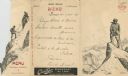
| Date: | 07 03 1908 |
|---|---|
| Description: | Foldout menu from the Hotel Müller, with two men using a pick and line to ascend a mountain on the flap, which opens to reveal the men as they attain the s... |
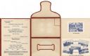
| Date: | 09 05 1926 |
|---|---|
| Description: | Dinner menu for the Hotel Witter, with menu listing, flap, front, and back of self-folding mailer, and tipped-in photographic views of the dining room and ... |
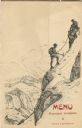
| Date: | 07 03 1908 |
|---|---|
| Description: | Folded menu from the Hotel Müller, with hikers on the die cut flap, ascending a mountain, and mountains and sky on the panel beneath. The drawings are sign... |
If you didn't find the material you searched for, our Library Reference Staff can help.
Call our reference desk at 608-264-6535 or email us at:
