 Filter: Categories of Wisconsin Historical Images
Filter: FORMAT_TYPE of drawings
Filter: Year of 1900-1999
Filter: County of Jefferson
Filter: Categories of Wisconsin Historical Images
Filter: FORMAT_TYPE of drawings
Filter: Year of 1900-1999
Filter: County of Jefferson

| Date: | 04 26 1935 |
|---|---|
| Description: | Drawing submitted to the State of Wisconsin for trademark registration. The drawing includes the word "Progressive" in blue and white letters over the shap... |

| Date: | 1947 |
|---|---|
| Description: | An ink on paper, hand-drawn map of Jefferson County, Wisconsin, that identifies named hills, other points of interest, and the Lake Mills moraine system in... |
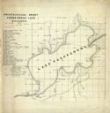
| Date: | 06 30 1907 |
|---|---|
| Description: | Map is ink on tracing paper. The left margin has an index of archeological sites around Koshkonong Lake. Lake Koshkonong is labelled. |

| Date: | 1941 |
|---|---|
| Description: | This map is ink and watercolor on cardboard and shows Native American legends and villages pictorially. Trails are also shown. |
If you didn't find the material you searched for, our Library Reference Staff can help.
Call our reference desk at 608-264-6535 or email us at: