 Filter: Categories of Wisconsin Historical Images
Filter: FORMAT_TYPE of drawings
Filter: Year of 1800-1899
Filter: Year of 1820-1829
Filter: Categories of Wisconsin Historical Images
Filter: FORMAT_TYPE of drawings
Filter: Year of 1800-1899
Filter: Year of 1820-1829

| Date: | 1820 |
|---|---|
| Description: | A manuscript map of Prairie du Chien. |
| Date: | 1827 |
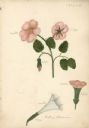
|---|---|
| Description: | Drawings of Datura Stramonium, more commonly known by the names jimson weed, devil's trumpet, devil's weed, thorn apple, tolguacha, Jamestown weed, stinkwe... |
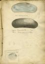
| Date: | 1828 |
|---|---|
| Description: | Increase Lapham's drawings of Unio plicatus and Unio radiatum (?) from the Scioto River, Cypraea tigris (Tiger cowry), and an Atlantic... |
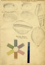
| Date: | 1828 |
|---|---|
| Description: | Increase Lapham's drawing of a Union mondonta (or Unio soleniformis) shell. There are also two views of another shell drawn below and a drawi... |

| Date: | 1828 |
|---|---|
| Description: | Increase Lapham drawings of Poa pratensis, Festuca duriuscula, Lolium prenne, Alopecurus pratensis, Anthoxanthum odoratum |
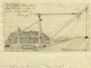
| Date: | 1827 |
|---|---|
| Description: | Increase Lapham's drawing of a rig designed by Mr. Orange Dibble for removing rocks and other large debris from deep canal cuts. |

| Date: | 1828 |
|---|---|
| Description: | Drawing by Increase Lapham showing the geological profile of the land between Utica and Knob Creek, Kentucky at a scale of 1/2 inch to a mile. |

| Date: | 1829 |
|---|---|
| Description: | This map of Munnomonee is ink and pencil on tracing cloth. The map shows a plat of the town, local streets, highways, land donations for public use, and pa... |

| Date: | 1828 |
|---|---|
| Description: | This plat map is pen-and-ink and shows landowners, the Mississippi River, the Marais de St. Friole, Fort Crawford, the town commons, and the Village of St.... |

| Date: | 1828 |
|---|---|
| Description: | This map is pen-and-ink and served as the model for the lithograph produced in 1828 by C.B. Graham. Landowners are labeled as is the Mississippi River. |
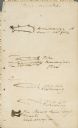
| Date: | 08 05 1820 |
|---|---|
| Description: | Sketches of Native American marks in James Doty's travel journal. Most of the marks represent different types of fish. |
If you didn't find the material you searched for, our Library Reference Staff can help.
Call our reference desk at 608-264-6535 or email us at:
