Filter: Categories of Wisconsin Historical Images
Filter: FORMAT_TYPE of drawings
Filter: Subject of water
Filter: Categories of Wisconsin Historical Images
Filter: FORMAT_TYPE of drawings
Filter: Subject of water

| Date: | 1853 |
|---|---|
| Description: | Farwell's Mill on the Yahara River at Lake Mendota. |
| Date: | 1900 |
|---|---|
| Description: | A drawing of Levee Park in La Crosse, with the Mississippi River in the foreground, and La Crosse in the background. |
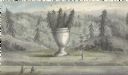
| Date: | |
|---|---|
| Description: | Artists depiction of a natural rock formation called "The Urn," which is 17 feet tall with another 10 feet of trees growing on top of the formation. |
| Date: | 1870 |
|---|---|
| Description: | One of the etchings published in an atlas of Lake County, Illinios in 1870 by George Ogle. Etchings done by the Wisconsin Central Railroad. |

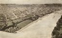
| Date: | 1885 |
|---|---|
| Description: | Illustrated view of Superior, as well as Omaha, Kansas City, St. Paul, and Winnipeg. Caption reads: "Superior - The Last Possible Great Marine City in the ... |

| Date: | 07 01 1836 |
|---|---|
| Description: | Original plat map of the town of Madison on the four lakes. |

| Date: | 1830 |
|---|---|
| Description: | Fort Winnebago from an original drawing by Jefferson Davis. |

| Date: | 1820 |
|---|---|
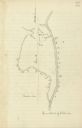
| Description: | A manuscript map of Prairie du Chien. |
| Date: | |
|---|---|
| Description: | Drawn map of the Catawba River, fishing creek, and surrounding landscape from the Sumter Papers. |

| Date: | 06 28 1958 |
|---|---|
| Description: | Official plat map drawn in ink and watercolor, T. 15 N, R. 11 E. |

| Date: | |
|---|---|
| Description: | An original ink drawing of William Donahey's "Teenie Weenies." This colorful drawing features several Teenie Weenies gathered around a mallard duck with te... |
| Date: | |
|---|---|
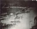
| Description: | Log raft and paddle steamer on the mouth of the Black River. On the banks of the river, there are buildings of a town visible. |

| Date: | |
|---|---|
| Description: | Hand-drawn, folded extension of map, rendered on notebook paper. |

| Date: | 1849 |
|---|---|
| Description: | Pencil sketch of a cross-section of the Dells of the Wisconsin River. People are in a row boat in the center. Caption at bottom: "The Dells — Wisconsin Riv... |
| Date: | 1885 |
|---|---|
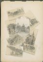
| Description: | Wisconsin State Capitol surrounded by seven miniature drawings of Madison images. |
| Date: | 08 31 1885 |
|---|---|
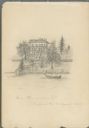
| Description: | Pencil on paper drawing of large house on hill above river, with rowboat and boathouse. The house has three stories, four chimneys, mansard roof, and long... |
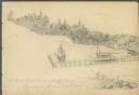
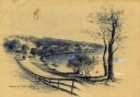
| Date: | 08 24 1885 |
|---|---|
| Description: | Pencil on paper; promontory shoreline with houses, trees, and church in background sweeping to right, with long pier jutting into lake. Two boats tied to ... |
If you didn't find the material you searched for, our Library Reference Staff can help.
Call our reference desk at 608-264-6535 or email us at: