 Filter: Categories of Wisconsin Historical Images
Filter: FORMAT_TYPE of drawings
Filter: Subject of water
Filter: County of Dane
Filter: Categories of Wisconsin Historical Images
Filter: FORMAT_TYPE of drawings
Filter: Subject of water
Filter: County of Dane

| Date: | 1851 |
|---|---|
| Description: | Plat map of the Town of Madison (Township 7N, Range 9E), from Volume 4, Federal Survey Plat Books. |

| Date: | 1832 |
|---|---|
| Description: | Hand-drawn map in two parts of the route of Governor J.D. Doty. Probably made by Doty in 1832 as a result of his travels with Alexander J. Center. |

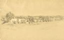
| Date: | 1852 |
|---|---|
| Description: | Pencil drawing of Madison landscape as seen from University Hill. The main street in the center is State Street, and the building with Greek columns in the... |

| Date: | 1852 |
|---|---|
| Description: | Pencil drawing of view overlooking Madison. The sketch looks down North Hamilton Street from the capitol. Rutted, irregular streets and frame houses mark ... |
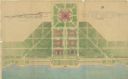
| Date: | 1938 |
|---|---|
| Description: | Reproduction of a color rendering of Olin Terraces, an early proposal for a Madison civic center by Frank Lloyd Wright. This perspective is the view from ... |

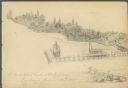
| Date: | 1853 |
|---|---|
| Description: | Farwell's Mill on the Yahara River at Lake Mendota. |

| Date: | 07 01 1836 |
|---|---|
| Description: | Original plat map of the town of Madison on the four lakes. |
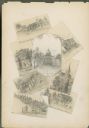
| Date: | 1885 |
|---|---|
| Description: | Wisconsin State Capitol surrounded by seven miniature drawings of Madison images. |
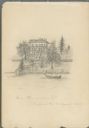
| Date: | 08 31 1885 |
|---|---|
| Description: | Pencil on paper drawing of large house on hill above river, with rowboat and boathouse. The house has three stories, four chimneys, mansard roof, and long... |
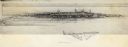
| Date: | 08 24 1885 |
|---|---|
| Description: | Pencil on paper; promontory shoreline with houses, trees, and church in background sweeping to right, with long pier jutting into lake. Two boats tied to ... |
| Date: | 1852 |
|---|---|
| Description: | Pencil drawing of trees around the shore of a lake from across a field. |

| Date: | 1941 |
|---|---|
| Description: | Hand-drawn, watercolor and ink, map of Lake Mendota. Locations and many small figures appear around the shore with explanations referring to Indian legends... |

| Date: | 1906 |
|---|---|
| Description: | Hand-drawn topographical map of the Turville Estate. |

| Date: | 1906 |
|---|---|
| Description: | Topographical map of Turville Point and lands to the South to Nine Springs Creek. |

| Date: | 1880 |
|---|---|
| Description: | This map is pen-and-ink on paper. The map shows buildings, trees, and water and gas pipes, relief is shown by contours. The back of the map reads: "Univers... |

| Date: | 1906 |
|---|---|
| Description: | This map is pen-and-ink on paper. The relief is shown by contours and spot heights. "5’ contours." Includes area table. |

| Date: | 1857 |
|---|---|
| Description: | This map is ink and pencil on tracing paper. The map shows plats of a western section of Madison. The lakes are labeled "Fourth Lake", "Third Lake" and "La... |
| Date: | 07 1939 |
|---|---|
| Description: | An architectural rendering of a proposed lakefront development plan. |

| Date: | |
|---|---|
| Description: | Detail from a drawing of a plan for the isthmus. |

| Date: | 1910 |
|---|---|
| Description: | This maps is pen and pencil on tracing cloth and shows local streets, buildings, proposed and present branches of railroad track, and sewer and water lines... |
If you didn't find the material you searched for, our Library Reference Staff can help.
Call our reference desk at 608-264-6535 or email us at: