 Filter: Categories of Wisconsin Historical Images
Filter: FORMAT_TYPE of drawings
Filter: Subject of water
Filter: Creator Name of Unknown
Filter: Categories of Wisconsin Historical Images
Filter: FORMAT_TYPE of drawings
Filter: Subject of water
Filter: Creator Name of Unknown

| Date: | 1872 |
|---|---|
| Description: | The sidewheel packet, Red Wing, in the Mississippi River near Queen's Bluff below Trempealeau, Wisconsin. |

| Date: | 1780 |
|---|---|
| Description: | Hand-drawn plan for the layout of the town of Clarksville, bordering Mayfield Creek and Liberty Creek. Fort Jefferson is shown between the townsite and the... |

| Date: | |
|---|---|
| Description: | Colorized view depicting the Wisconsin Central Railroad bridge at Stevens Point, with several men standing on top of the bridge painting the structure. Cap... |
| Date: | 1938 |
|---|---|
| Description: | Reproduction of a color rendering of Olin Terraces, an early proposal for a Madison civic center by Frank Lloyd Wright. This perspective is the view from ... |

| Date: | |
|---|---|
| Description: | A Menominee Indian Village on Wolf River. There are dwellings on the shore and many people in canoes are on the river. |
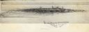
| Date: | 1870 |
|---|---|
| Description: | Sketch of the Fox River, a train, the mill, a warehouse, and a steamboat. |
| Date: | 1850 |
|---|---|
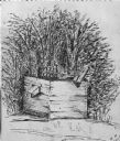
| Description: | Black and white ink drawing of an old wooden well. |
| Date: | |
|---|---|
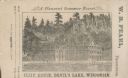
| Description: | View of the Cliff House on the lake, with pine trees surrounding the property, and a cliff behind the building. |

| Date: | 1851 |
|---|---|
| Description: | Several men rowing in a boat near Fort Howard that has an American Flag, barracks, and various related military buildings enclosed behind a wall. |
| Date: | 1876 |
|---|---|
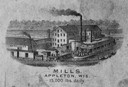
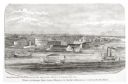
| Description: | View looking southeast over river from Elmore and Kelly's Elevator. |

| Date: | 1885 |
|---|---|
| Description: | Illustrated view of Superior, as well as Omaha, Kansas City, St. Paul, and Winnipeg. Caption reads: "Superior - The Last Possible Great Marine City in the ... |

| Date: | 07 01 1836 |
|---|---|
| Description: | Original plat map of the town of Madison on the four lakes. |

| Date: | 06 28 1958 |
|---|---|
| Description: | Official plat map drawn in ink and watercolor, T. 15 N, R. 11 E. |
| Date: | |
|---|---|
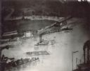
| Description: | Log raft and paddle steamer on the mouth of the Black River. On the banks of the river, there are buildings of a town visible. |

| Date: | |
|---|---|
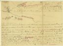
| Description: | Hand-drawn, folded extension of map, rendered on notebook paper. |
| Date: | |
|---|---|
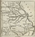
| Description: | Map of Missouri with major cities, rivers, and railroads marked. |
| Date: | |
|---|---|
| Description: | A hand-drawn map of the Boone camps on the Kentucky River. |

| Date: | 11 26 1883 |
|---|---|
| Description: | A hand-drawn map of the Clinch and Powell's Valleys, including the Cumberland Mountains, Powell's Mountains and Clinch Mountains. |
If you didn't find the material you searched for, our Library Reference Staff can help.
Call our reference desk at 608-264-6535 or email us at:

