 Filter: Categories of Wisconsin Historical Images
Filter: FORMAT_TYPE of drawings
Filter: Subject of voyages and travels
Filter: Categories of Wisconsin Historical Images
Filter: FORMAT_TYPE of drawings
Filter: Subject of voyages and travels
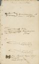
| Date: | 08 05 1820 |
|---|---|
| Description: | Sketches of Native American marks in James Doty's travel journal. Most of the marks represent different types of fish. |
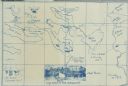
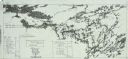
| Date: | 1914 |
|---|---|
| Description: | A map, hand-drawn by Carl Greene, of the McFarland Lake (Minnesota) region. The map also includes several clever, humorous drawings referring to some membe... |
| Date: | 1909 |
|---|---|
| Description: | A cyanoprint map of The Gang's journey down the Presque Isle River. There are small drawings around the border depicting the adventures of The Gang and Car... |

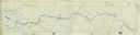
| Date: | 1909 |
|---|---|
| Description: | A hand-drawn and illustrated map of The Gang's trip from their seventh camp to Lake Superior. |
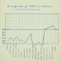
| Date: | 1909 |
|---|---|
| Description: | A hand-drawn cyanotype chart tracking Piffy's (Charles Isley's) morale. |
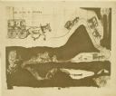
| Date: | 1910 |
|---|---|
| Description: | Carl Greene's drawing of a map of The Gang's trip to Winton, titled "We drive to Winton." This map shows a road currently known as the Thirteen Corners Roa... |
| Date: | |
|---|---|
| Description: | A blueprint map with an overlay traced in pencil of the routes of Howard Greene and The Gang's 1910 and 1911 canoe trips. |
If you didn't find the material you searched for, our Library Reference Staff can help.
Call our reference desk at 608-264-6535 or email us at: