 Filter: Categories of Wisconsin Historical Images
Filter: FORMAT_TYPE of drawings
Filter: Subject of transportation
Filter: Categories of Wisconsin Historical Images
Filter: FORMAT_TYPE of drawings
Filter: Subject of transportation
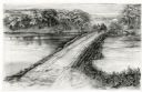
| Date: | 1948 |
|---|---|
| Description: | Drawing depicting a horse-drawn carriage crossing a stone and log causeway built across a river. |
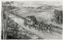
| Date: | 1948 |
|---|---|
| Description: | Drawing of a Madison to Prairie du Chien stage coach in 1848. The coach is driven by two men and drawn by four horses as it passes a farm field separated f... |
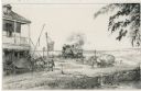
| Date: | 1948 |
|---|---|
| Description: | Drawing of a passenger train approaching a small town where two teams of horses on a plank road appear to be startled by the noise of the locomotive. One t... |

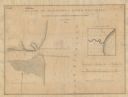
| Date: | 07 1868 |
|---|---|
| Description: | A hand-drawn map of a portion of Jackson County, Wisconsin between Township No. 21 north, range number 4 West and township no. 21 north, range no. 3 west, ... |

| Date: | 12 25 1942 |
|---|---|
| Description: | This hand-drawn map shows the highways and features in the Rock Lake-Lake Mills area in the towns of Aztalan and Lake Mills, Jefferson County, Wisconsin. T... |

| Date: | 1897 |
|---|---|
| Description: | Topographical map of Stanley McCormick's Riven Rock estate in El Montecito, Santa Barbara County, California. The map is identified as a map of a survey co... |

| Date: | 1899 |
|---|---|
| Description: | Topographical map showing ridges, water courses, boundary lines, and trails and roads near the Stanley McCormick's Riven Rock estate in El Montecito, Santa... |

| Date: | 1899 |
|---|---|
| Description: | Overhead map of the Stanley McCormick's Riven Rock estate in El Montecito, Santa Barbara, California. The map shows the placement of dwellings and fields, ... |

| Date: | 1899 |
|---|---|
| Description: | A map showing the shoreline of a portion of El Montecito, Santa Barbara County, California. The map shows properties along the Pacific Ocean, and may have ... |

| Date: | 1830 |
|---|---|
| Description: | An ink on paper, hand-drawn map, showing the wagons roads that travel through Lafayette County, traveling between Galena, Illinois, and Mineral Point, Wisc... |
| Date: | 1836 |
|---|---|
| Description: | A hand-drawn map of the mouth of the Manitowoc River at Lake Michigan, showing depth of the water by contour lines. The included inset map shows the region... |

| Date: | |
|---|---|
| Description: | An ink, watercolor, and pencil on paper, hand-drawn map that shows the Michigan-Wisconsin boundary in Iron, Vilas, Forest, Florence, and Marinette counties... |

| Date: | 1840 |
|---|---|
| Description: | An ink, watercolor, and pencil on tracing paper, hand-drawn map of Milwaukee County, Wisconsin that shows the town and range system, sections, lakes and st... |

| Date: | 1844 |
|---|---|
| Description: | An ink on paper, hand-drawn map of Milwaukee County that shows the sectioning of townships, the boundary of the canal grant, roads, streams, lakes, includi... |

| Date: | 1837 |
|---|---|
| Description: | A pen and ink on tracing paper, hand-drawn and colored map the proposed route of the Milwaukee and Rock River Canal, ranging from the Rock River in the wes... |

| Date: | 1800 |
|---|---|
| Description: | This 19th-century manuscript map of the Town of Newton, Manitowoc County, Wisconsin, shows sections, lakes and streams, the trail from Chicago to Green Bay... |

| Date: | 1875 |
|---|---|
| Description: | This manuscript map by Increase Lapham, drawn in the last year of his life, shows landownership, roads and railroads, springs, and boat houses around Ocono... |
| Date: | 1845 |
|---|---|
| Description: | This manuscript map, drawn about 1845, shows the township and range grid, villages, post offices, and roads in Kenosha, Racine, and Walworth counties and i... |

| Date: | 1836 |
|---|---|
| Description: | This manuscript shows the 1835 survey of the road corresponding approximately to a portion of County Trunk A in the Town of Scott, Brown County, Wisconsin.... |

| Date: | 1837 |
|---|---|
| Description: | This manuscript map, copied in 1837 from a map in the Green Bay Land Office, Navarino, shows sections, the Shebowegan Trail, sandstone ledges, rivers, stre... |
If you didn't find the material you searched for, our Library Reference Staff can help.
Call our reference desk at 608-264-6535 or email us at: