 Filter: Categories of Wisconsin Historical Images
Filter: FORMAT_TYPE of drawings
Filter: Subject of trails
Filter: Categories of Wisconsin Historical Images
Filter: FORMAT_TYPE of drawings
Filter: Subject of trails

| Date: | 1936 |
|---|---|
| Description: | This map is red and black ink on tracing cloth and is oriented with north to the upper left. This hand-drawn map shows a central portion of the military ro... |
| Date: | 05 27 1849 |
|---|---|
| Description: | The wagon train crossing Laramie Creek in Wyoming. |
| Date: | 1849 |
|---|---|
| Description: | Fort Childs or New Fort Kearny in Nebraska Sketched by Wilkins on his 151-day journey from Missouri to California on the Overland Trail (also known as the ... |
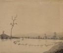
| Date: | 05 1849 |
|---|---|
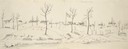
| Description: | Deserted Pawnee village in Nebraska. Sketched by Wilkins on his 151-day journey from Missouri to California on the Overland Trail (also known as the Oregon... |
| Date: | 05 1849 |
|---|---|
| Description: | Old Fort Kearney (Nebraska City). Sketched by Wilkins on his 151-day journey from Missouri to California on the Overland Trail (also known as the Oregon Tr... |

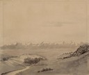
| Date: | 06 24 1849 |
|---|---|
| Description: | Original wash drawing of Fort Laramie, Wyoming (actually Fort John; see note below). Sketched by Wilkins on his 151-day journey from Missouri to California... |
| Date: | 05 1849 |
|---|---|
| Description: | Fort Leavenworth with trees, buildings and American flag. The fort was established by Colonel Henry Leavenworth to protect the Santa Fe trail against the I... |
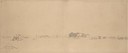
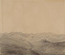
| Date: | 06 20 1849 |
|---|---|
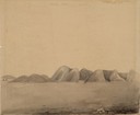
| Description: | The Black Hills sketched by Wilkins on his 151-day journey from Missouri to California on the Overland Trail (also known as the Oregon Trail). |
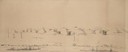
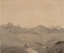
| Date: | 06 30 1849 |
|---|---|
| Description: | The Red Hills sketched by Wilkins on his 151-day journey from Missouri to California on the Overland Trail (also known as the Oregon Trail). |
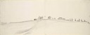
| Date: | 06 30 1849 |
|---|---|
| Description: | The Black Hills sketched by Wilkins on his 151-day journey from Missouri to California on the Overland Trail (also known as the Oregon Trail). |
| Date: | 06 30 1849 |
|---|---|
| Description: | The Black Hills sketched by Wilkins on his 151-day journey from Missouri to California on the Overland Trail (also known as the Oregon Trail). |
| Date: | 07 12 1849 |
|---|---|
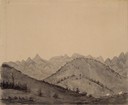
| Description: | Wilkins' first sighting of the Rocky Mountains; sketched by Wilkins on his 151-day journey from Missouri to California on the Overland Trail (also known as... |
| Date: | 07 13 1849 |
|---|---|
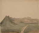
| Description: | The trail at Rocky Ridge, showing wagon train, that Wilkins was taking to get to the South Pass in Wyoming; sketched by Wilkins on his 151-day journey from... |
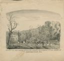
| Date: | |
|---|---|
| Description: | "Conveying Provisions over the Ozark Mountains to the Army at Springfield, MO." Men on horseback are riding along a trail carrying supplies. |

| Date: | 1899 |
|---|---|
| Description: | Topographical map showing ridges, water courses, boundary lines, and trails and roads near the Stanley McCormick's Riven Rock estate in El Montecito, Santa... |

| Date: | 1800 |
|---|---|
| Description: | This 19th-century manuscript map of the Town of Newton, Manitowoc County, Wisconsin, shows sections, lakes and streams, the trail from Chicago to Green Bay... |

| Date: | 1837 |
|---|---|
| Description: | This manuscript map, copied in 1837 from a map in the Green Bay Land Office, Navarino, shows sections, the Shebowegan Trail, sandstone ledges, rivers, stre... |

| Date: | 08 24 1899 |
|---|---|
| Description: | Pen-and-ink and color on paper. Also shows probable routes of the French explorers Constant le Marchand de Lignery in 1728 and Louis de la Porte de Louvign... |

| Date: | 1800 |
|---|---|
| Description: | This map of the Little Kaukalin Region is ink on paper and shows Little Kaukalin Rapids, Black Bird Island, buildings, trails, meadows and woods, and a sug... |

| Date: | 1800 |
|---|---|
| Description: | This map is pencil on tracing paper and shows marshes, the Wisconsin River, Indian trails, and Indian boundary line. The upper left corner reads: "Let sect... |
If you didn't find the material you searched for, our Library Reference Staff can help.
Call our reference desk at 608-264-6535 or email us at: