 Filter: Categories of Wisconsin Historical Images
Filter: FORMAT_TYPE of drawings
Filter: Subject of superior, lake
Filter: Categories of Wisconsin Historical Images
Filter: FORMAT_TYPE of drawings
Filter: Subject of superior, lake
| Date: | 1870 |
|---|---|
| Description: | One of the etchings published in an atlas of Lake County, Illinios in 1870 by George Ogle. Etchings done by the Wisconsin Central Railroad. |

| Date: | 1885 |
|---|---|
| Description: | Illustrated view of Superior, as well as Omaha, Kansas City, St. Paul, and Winnipeg. Caption reads: "Superior - The Last Possible Great Marine City in the ... |

| Date: | |
|---|---|
| Description: | Hand-drawn, folded extension of map, rendered on notebook paper. |

| Date: | 1916 |
|---|---|
| Description: | A pen on paper, hand-drawn map that shows the railroads, rivers, county outlines, and cities and villages in Wisconsin, northern Illinois, and the western ... |

| Date: | 1866 |
|---|---|
| Description: | A pen on paper, hand-drawn and colored map of Wisconsin and Michigan, showing counties, cities and villages, rivers and lakes, as well as railroads are in ... |

| Date: | 1866 |
|---|---|
| Description: | A pen on paper, hand-drawn and colored map of Wisconsin and Michigan, showing counties, cities and villages, rivers and lakes, as well as railroads are in ... |

| Date: | 1912 |
|---|---|
| Description: | This map is pen, ink, and pencil on tracing paper. The map was traced from U.S. Geological Survey map of Wisconsin, compiled in 1910-1911, and printed in 1... |

| Date: | |
|---|---|
| Description: | A hand-drawn Geological map of the Upper Peninsula of Michigan, showing the counties and streams of that area. The map also identifies the location of the... |
| Date: | 1909 |
|---|---|
| Description: | A cyanoprint map of The Gang's journey down the Presque Isle River. There are small drawings around the border depicting the adventures of The Gang and Car... |

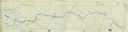
| Date: | 1909 |
|---|---|
| Description: | A hand-drawn and illustrated map of The Gang's trip from their seventh camp to Lake Superior. |
If you didn't find the material you searched for, our Library Reference Staff can help.
Call our reference desk at 608-264-6535 or email us at:
