 Filter: Categories of Wisconsin Historical Images
Filter: FORMAT_TYPE of drawings
Filter: Subject of suburbs
Filter: Categories of Wisconsin Historical Images
Filter: FORMAT_TYPE of drawings
Filter: Subject of suburbs

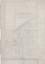
| Date: | 06 08 1960 |
|---|---|
| Description: | Blueprint plat of Sunset Hills sub-division. |
| Date: | 03 03 1937 |
|---|---|
| Description: | A pencil drawing of a proposed area of the planned community of Greendale, Wisconsin. The community was established as an objective of the Department of Ag... |
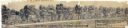
| Date: | 1938 |
|---|---|
| Description: | Architectural drawing of the Sunset Village neighborhood on the West side of the city of Madison. The poster description reads: A proposed master plan for ... |

| Date: | 1969 |
|---|---|
| Description: | This map is pen and ink on paper and shows the location of churches, local streets, railroads, parks, Middleton, Shorewood Hills, Monona, Maple Bluff, McFa... |
If you didn't find the material you searched for, our Library Reference Staff can help.
Call our reference desk at 608-264-6535 or email us at: