Filter: Categories of Wisconsin Historical Images
Filter: FORMAT_TYPE of drawings
Filter: Subject of mississippi river
Filter: Categories of Wisconsin Historical Images
Filter: FORMAT_TYPE of drawings
Filter: Subject of mississippi river

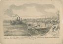
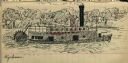
| Date: | 1872 |
|---|---|
| Description: | The sidewheel packet, Red Wing, in the Mississippi River near Queen's Bluff below Trempealeau, Wisconsin. |

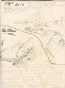
| Date: | 1780 |
|---|---|
| Description: | Hand-drawn plan for the layout of the town of Clarksville, bordering Mayfield Creek and Liberty Creek. Fort Jefferson is shown between the townsite and the... |
| Date: | |
|---|---|
| Description: | Drawing of a section of a completed part of Fort Cairo facing the confluen [sic] of the Mississippi and Ohio rivers. |

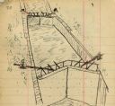
| Date: | |
|---|---|
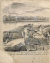
| Description: | "Building rafts, or pontoons, upon which to mount huge mortars — for use on the river. Scene at St. Louis." Men are building on a pontoon with lumber. Ther... |
| Date: | 04 1862 |
|---|---|
| Description: | Notes include: Sketch of Battle of Island #10. Sketch of Fort Pillow Tennessee. Gen. Pope had command of the land troops. |
| Date: | 05 1862 |
|---|---|
| Description: | "Hamburg Landing, 4 miles below Pittsburg Landing, Commisary [sic] Depot of Gen. Hallek's Army." An encampment with soldiers along the river with a ... |

| Date: | 1862 |
|---|---|
| Description: | An image from a sketchbook of "The Gunboats at No. 10 — Eve of Arrival before the I'sld". The drawing appears to be from the deck of a ship showing several... |
| Date: | 1862 |
|---|---|
| Description: | This is the preliminary sketch for "Hamburg Landing, 4 miles below Pittsburg Landing, Commisary [sic] Depot of Gen. Hallek's Army." Shows an encampm... |
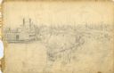
| Date: | 1900 |
|---|---|
| Description: | A drawing of Levee Park in La Crosse, with the Mississippi River in the foreground, and La Crosse in the background. |

| Date: | 1820 |
|---|---|
| Description: | A manuscript map of Prairie du Chien. |
| Date: | 1903 |
|---|---|
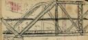
| Description: | Lock and dam system on a canal along the Mississippi River. |
| Date: | 1903 |
|---|---|
| Description: | Drawing of the steamboat Weyerhauser on the Mississippi River. |
| Date: | 1903 |
|---|---|
| Description: | Drawing of the "Rambo" and "Musser" transporting a log raft on the Mississippi River. |

| Date: | 1835 |
|---|---|
| Description: | Ink on tracing paper map of Green Bay, Wisconsin and nearby areas, Lake Winnebago, Fox and Wolf Rivers, and the junctions of the Mississippi and Wisconsin ... |

| Date: | 1916 |
|---|---|
| Description: | A pen on paper, hand-drawn map that shows the railroads, rivers, county outlines, and cities and villages in Wisconsin, northern Illinois, and the western ... |

| Date: | 1866 |
|---|---|
| Description: | A pen on paper, hand-drawn and colored map of Wisconsin and Michigan, showing counties, cities and villages, rivers and lakes, as well as railroads are in ... |

| Date: | 1838 |
|---|---|
| Description: | This manuscript map, drawn in pencil, shows the lakes and rivers in the area between Lake of the Woods in northern Minnesota, the Mississippi River on the ... |

| Date: | 1912 |
|---|---|
| Description: | This map is pen, ink, and pencil on tracing paper. The map was traced from U.S. Geological Survey map of Wisconsin, compiled in 1910-1911, and printed in 1... |

| Date: | 1920 |
|---|---|
| Description: | An ink on tracing paper, hand-drawn map that shows lead mines, the boundary of the lead bearing strata, and the military road in Lafayette, Grant, Iowa, an... |
If you didn't find the material you searched for, our Library Reference Staff can help.
Call our reference desk at 608-264-6535 or email us at: