 Filter: Categories of Wisconsin Historical Images
Filter: FORMAT_TYPE of drawings
Filter: Subject of land use, urban
Filter: Categories of Wisconsin Historical Images
Filter: FORMAT_TYPE of drawings
Filter: Subject of land use, urban
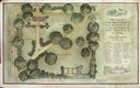
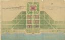
| Date: | 1915 |
|---|---|
| Description: | Drawings and blueprints of the arrangement and planting design of a small town. |

| Date: | |
|---|---|
| Description: | Design for Wisconsin Centennial 3 cent postage stamp featuring a dairy and agriculture theme. |

| Date: | 07 01 1836 |
|---|---|
| Description: | Original plat map of the town of Madison on the four lakes. |

| Date: | 1905 |
|---|---|
| Description: | A drawing by State Architect, Arthur Peabody, depicting the proposed State Street facade of the University Club building. |
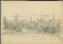
| Date: | 08 26 1885 |
|---|---|
| Description: | Pencil on paper; view from Bascom Hill, with buildings, churches, on the right side of street, Wisconsin State Capitol in background, with trees surroundin... |
| Date: | 09 01 1885 |
|---|---|
| Description: | Pencil on paper; Elevated view of building on street corner with horse-drawn delivery wagon in front. Tall trees line the two streets. Building is two st... |
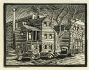
| Date: | |
|---|---|
| Description: | Woodblock print of an urban scene with cars parked along the curb near a garage. |
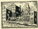
| Date: | |
|---|---|
| Description: | Woodblock print of an urban street scene with a clothesline strung between buildings, and a church and a hamburger joint. |
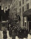
| Date: | 02 1932 |
|---|---|
| Description: | Engraving by Charles Silver to mark the passage of Wisconsin's Unemployment Compensation Law, the first in the nation. |

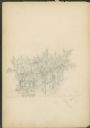
| Date: | 1829 |
|---|---|
| Description: | This map of Munnomonee is ink and pencil on tracing cloth. The map shows a plat of the town, local streets, highways, land donations for public use, and pa... |

| Date: | 1850 |
|---|---|
| Description: | This map of the Town of Lake is ink and pencil on paper and shows lots and acreages, reserved land, and public squares. The bottom of the map includes a ke... |
| Date: | 07 1939 |
|---|---|
| Description: | An architectural rendering of a proposed lakefront development plan. |
If you didn't find the material you searched for, our Library Reference Staff can help.
Call our reference desk at 608-264-6535 or email us at: