Filter: Categories of Wisconsin Historical Images
Filter: FORMAT_TYPE of drawings
Filter: Subject of land use
Filter: Categories of Wisconsin Historical Images
Filter: FORMAT_TYPE of drawings
Filter: Subject of land use

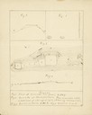
| Date: | 1833 |
|---|---|
| Description: | Township/section map showing Rodolf land and nearby neighbors. |

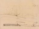
| Date: | 1834 |
|---|---|
| Description: | Peck-a-ton-oka (Pecatonica River) with Rodolf farm in the background. |
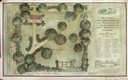
| Date: | 1915 |
|---|---|
| Description: | Drawings and blueprints of the arrangement and planting design of a small town. |

| Date: | 1780 |
|---|---|
| Description: | Plan for layout of 150,00 acres which make up Clark's Illinois Grant. |
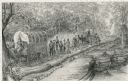
| Date: | 1948 |
|---|---|
| Description: | Pencil drawing of men building a corderoy road in the 1860's. Used for historical display for the Wisconsin State Highway Department. |

| Date: | 1876 |
|---|---|
| Description: | A sketch map of the procession of Indian mounds on the two ridged field sites in Grant County. |
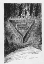
| Date: | |
|---|---|
| Description: | Pencil sketch, drawn by Frank Lloyd Wright, possibly of a wooden privacy fence. The sketch shows an elevation and a site plan. |

| Date: | 1850 |
|---|---|
| Description: | Lithograph of a map drawn to indicate a mine on land owned by Mineral Point Mining Co. in the lead region of southwestern Wisconsin. |
| Date: | 1655 |
|---|---|
| Description: | Front view of the Radisson cabin, the first house built by a white man in Wisconsin. It was built between 1650 and 1660 on Chequamegon Bay, in the vicinity... |
| Date: | 05 1849 |
|---|---|
| Description: | A farm in Missouri with one wagon visible. Sketched by Wilkins on his 151-day journey from Missouri to California on the Overland Trail (also known as the ... |
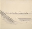
| Date: | 05 1849 |
|---|---|
| Description: | The bottom lands and a farm in Missouri; Sketched by Wilkins on his 151-day journey from Missouri to California on the Overland Trail (also known as the Or... |
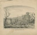
| Date: | |
|---|---|
| Description: | "Conveying Provisions over the Ozark Mountains to the Army at Springfield, MO." Men on horseback are riding along a trail carrying supplies. |
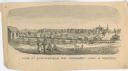
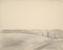
| Date: | 1861 |
|---|---|
| Description: | "View of Springfield, MO. Frmonts [sic] Army in Possesion [sic]." Several people and a horse are in the foreground, and city buildings are in... |
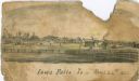
| Date: | 1866 |
|---|---|
| Description: | An image from a sketchbook of the town of Iowa Falls. There is a fence in the foreground and buildings in the background. |
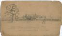
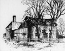
| Date: | |
|---|---|
| Description: | Home of Notorious Rebel — E.L. Newsome (located in New Madrid, Missouri). There is a farmstead with a man and woman in the foreground, a fence in the middl... |
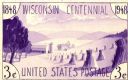
| Date: | |
|---|---|
| Description: | Design in purple for the Wisconsin Centennial 3 cent postage stamp. There is a farming theme, with stacks of grain and a barn. |
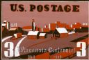
| Date: | |
|---|---|
| Description: | Design in shades of red for 3 cent Wisconsin Centennial postage stamp with farming and industry theme. |

| Date: | |
|---|---|
| Description: | Design for Wisconsin Centennial 3 cent postage stamp featuring a dairy and agriculture theme. |
If you didn't find the material you searched for, our Library Reference Staff can help.
Call our reference desk at 608-264-6535 or email us at: