Filter: Categories of Wisconsin Historical Images
Filter: FORMAT_TYPE of drawings
Filter: Subject of intellectual life
Filter: Categories of Wisconsin Historical Images
Filter: FORMAT_TYPE of drawings
Filter: Subject of intellectual life
| Date: | |
|---|---|
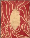
| Description: | Watercolor valentine written by a young man and given to one of the daughters of Louis Dousman, probably Violet or Virginia. |

| Date: | 1900 |
|---|---|
| Description: | Holy card with watercolor of a wreath of white flowers encircling an open book resting on a cross and crown of thorns. |
| Date: | |
|---|---|
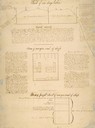
| Description: | Drawing of a time saving chart for one day's labor in a sawyard shop. |

| Date: | 1780 |
|---|---|
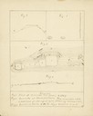
| Description: | Hand-drawn plan for the layout of the town of Clarksville, bordering Mayfield Creek and Liberty Creek. Fort Jefferson is shown between the townsite and the... |

| Date: | 1780 |
|---|---|
| Description: | Plan for layout of 150,00 acres which make up Clark's Illinois Grant. |
| Date: | 1979 |
|---|---|
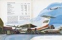
| Description: | Illustration from the annual report of Air Wisconsin, the first publicly held airline in the country. Air Wisconsin began in Appleton in 1963 after North ... |
| Date: | 1860 |
|---|---|
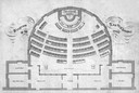
| Description: | Floor plan and seating chart for the Assembly for their first meeting in the East Wing of new Wisconsin State Capitol building. After the completion of th... |

| Date: | 1876 |
|---|---|
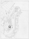
| Description: | A sketch map of the procession of Indian mounds on the two ridged field sites in Grant County. |
| Date: | 05 04 1886 |
|---|---|
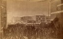
| Description: | Photograph of an artistic rendering of a rally held at Haymarket Square on May 4, 1886, before the explosion of the bomb. Haymarket Square is at the Inters... |

| Date: | 08 24 1876 |
|---|---|
| Description: | Hand-drawn plan of the battleground of Huycks. |

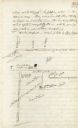
| Date: | 03 26 1876 |
|---|---|
| Description: | Hand-drawn map showing the place of Hook's defeat in York County in South Carolina. |

| Date: | 1850 |
|---|---|
| Description: | Lithograph of a map drawn to indicate a mine on land owned by Mineral Point Mining Co. in the lead region of southwestern Wisconsin. |
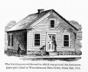
| Date: | 1857 |
|---|---|
| Description: | Green Bay Intelligencer Newspaper Office. This was the first newspaper published in Wisconsin. The building was on Main Street. This drawing appeared in an... |

| Date: | |
|---|---|
| Description: | A very vague sketch of a map of North Racine, Wisconsin. |
| Date: | |
|---|---|
| Description: | A simple sketch of a section of Arkansas, showing the Arkansas River, White River and Helena, Arkansas. |

| Date: | 08 10 1862 |
|---|---|
| Description: | A hand-drawn map of the Battle of Wilson's Creek, Springfield, Missouri. Other notes and locations include: "Lyon was killed instantly while heading his tr... |
If you didn't find the material you searched for, our Library Reference Staff can help.
Call our reference desk at 608-264-6535 or email us at: