 Filter: Categories of Wisconsin Historical Images
Filter: FORMAT_TYPE of drawings
Filter: Subject of human settlements
Filter: Categories of Wisconsin Historical Images
Filter: FORMAT_TYPE of drawings
Filter: Subject of human settlements

| Date: | 1837 |
|---|---|
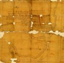
| Description: | A pen and ink on tracing paper, hand-drawn and colored map the proposed route of the Milwaukee and Rock River Canal, ranging from the Rock River in the wes... |

| Date: | 1830 |
|---|---|
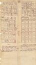
| Description: | An ink on paper, hand-drawn map of the town of Milwaukee, showing the divisions and landownership within the town by private individuals as well as those l... |

| Date: | 1800 |
|---|---|
| Description: | This 19th-century manuscript map of the Town of Newton, Manitowoc County, Wisconsin, shows sections, lakes and streams, the trail from Chicago to Green Bay... |

| Date: | 1875 |
|---|---|
| Description: | This manuscript map by Increase Lapham, drawn in the last year of his life, shows landownership, roads and railroads, springs, and boat houses around Ocono... |

| Date: | 1887 |
|---|---|
| Description: | This manuscript map of the southern portion of the Town of Porterfield, Marinette County, Wisconsin, shows sections and land ownership. The Menominee River... |

| Date: | |
|---|---|
| Description: | This 19th century manuscript map shows lots and acreages in northern Green Bay, Wisconsin, east of the Fox River. "Preble Township, Brown County, Wis." is ... |
| Date: | 1845 |
|---|---|
| Description: | This manuscript map, drawn about 1845, shows the township and range grid, villages, post offices, and roads in Kenosha, Racine, and Walworth counties and i... |

| Date: | |
|---|---|
| Description: | This 19th century manuscript map shows land claims near the confluence of the Wisconsin River with the Mississippi River in the Town of Bridgeport, Crawfor... |

| Date: | 1836 |
|---|---|
| Description: | This manuscript shows the 1835 survey of the road corresponding approximately to a portion of County Trunk A in the Town of Scott, Brown County, Wisconsin.... |
| Date: | |
|---|---|
| Description: | These 19th-century manuscript maps show the survey of much of Crawford County, Wisconsin. Plats for the towns of Prairie du Chien and Bridgeport and for th... |
| Date: | 1880 |
|---|---|
| Description: | This plat of Vanceburg Cemetery, Town of Sheridan, Dunn County, Wisconsin, likely dates from the 1880s and "is intended for the correction of names of peop... |

| Date: | 1712 |
|---|---|
| Description: | This drawing, based on an 1897 survey, appeared in the 1899 Proceedings of the State Historical Society of Wisconsin, accompanying Publius V. Lawson's arti... |

| Date: | 1800 |
|---|---|
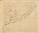
| Description: | This pen and ink drawing with watercolor shows the course of the Black River from Rock Creek, near Greenwood in Clark County, Wisconsin, to its confluence ... |

| Date: | 1864 |
|---|---|
| Description: | This map is pen and watercolor on paper and shows profile and geological formation of Blue Mound and location of Arnold’s Hotel and Brigham Lead Mines. |

| Date: | 01 09 1849 |
|---|---|
| Description: | Shows county line boundaries, rivers, and falls. Includes explanation of township and county divisions. Pen and pencil on paper. Title supplied by cataloge... |

| Date: | 1972 |
|---|---|
| Description: | Ink on tracing paper. This map shows rivers, Prairie du Chien, site of Fort Crawford, Excelsior, Fort Andrew, Boscobel, Blue River, Orion, Muscoda, Castle ... |

| Date: | 1913 |
|---|---|
| Description: | Ink and watercolor on tracing cloth. Shows parts of Green Lake, Princeton, and Brooklyn townships, Indian mound groups, Green Lake, and other significant b... |
| Date: | 1860 |
|---|---|
| Description: | Pencil and ink on paper. "Showing the government meander line on the left bank of Rock River and the actual course of Rock River together with the several ... |

| Date: | 1881 |
|---|---|
| Description: | Ink, watercolor, and pencil on paper. Top of the map reads: "NORTHERN OUTLET MENASHA MEANDER LINES Scale 132ft 1 INCH Var S.E. Survey Completed Spet. 23 18... |

| Date: | 1835 |
|---|---|
| Description: | This map is pen-and-ink on paper. The map shows landowners in "Milwalky" or present day Milwaukee. Includes "list of property offered to Mr. Walker". The m... |
If you didn't find the material you searched for, our Library Reference Staff can help.
Call our reference desk at 608-264-6535 or email us at: