Filter: Categories of Wisconsin Historical Images
Filter: FORMAT_TYPE of drawings
Filter: Subject of human settlements
Filter: Categories of Wisconsin Historical Images
Filter: FORMAT_TYPE of drawings
Filter: Subject of human settlements
| Date: | 1858 |
|---|---|
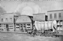
| Description: | View on North Water Street, showing the building in which the Bank of Sparta was founded. A man is walking beside a oxen pulling a covered wagon. |
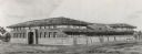
| Date: | 1899 |
|---|---|
| Description: | The Elisha D. Smith Library built by Van Ryn and De Gelleke. |

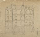
| Date: | 1890 |
|---|---|
| Description: | Benjamin Walker Castle, 1862-1893 in the 900 block of East Gorham Street. |
| Date: | |
|---|---|
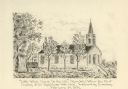
| Description: | Caption reads: "'Little White Church On the Hill' (Ripon, Wis.) Where the First Meeting of the Republicans Was Held, Wednesday Evening, February 29, 1854" |

| Date: | 1830 |
|---|---|
| Description: | Fort Winnebago from an original drawing by Jefferson Davis. |
| Date: | 1909 |
|---|---|
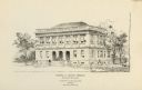
| Description: | Architectural drawing. Caption reads: "Market House for the City of Madison". Robert L. Wright, Milwaukee, architect. |

| Date: | 1820 |
|---|---|
| Description: | A manuscript map of Prairie du Chien. |
| Date: | |
|---|---|
| Description: | Drawn map of Landsford, South Carolina, from Thomas Sumter Papers. |

| Date: | 1949 |
|---|---|
| Description: | Artist rendition of the exterior view of the research and development tower of the Johnson Wax building. |

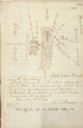
| Date: | 12 26 1862 |
|---|---|
| Description: | Handsketched map of the area around Knobs Gap. |
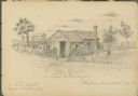
| Date: | 08 28 1885 |
|---|---|
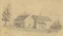
| Description: | Sketch of the shack from which Benedict Goldenberger sold cider vinegar. Possibly on Murray Street. |

| Date: | 06 28 1958 |
|---|---|
| Description: | Official plat map drawn in ink and watercolor, T. 15 N, R. 11 E. |
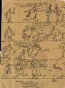
| Date: | 1954 |
|---|---|
| Description: | Comic strip showing man bombing a house because it is being sold to an African-American man. A police officer arrests the seller of the home for inciting t... |
| Date: | |
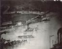
|---|---|
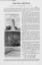
| Description: | Log raft and paddle steamer on the mouth of the Black River. On the banks of the river, there are buildings of a town visible. |

| Date: | |
|---|---|
| Description: | Hand-drawn, folded extension of map, rendered on notebook paper. |
| Date: | |
|---|---|
| Description: | A drawing of the old Post Office on the corner of Wisconsin Avenue and Mifflin Street. |
If you didn't find the material you searched for, our Library Reference Staff can help.
Call our reference desk at 608-264-6535 or email us at: