 Filter: Categories of Wisconsin Historical Images
Filter: FORMAT_TYPE of drawings
Filter: Subject of human settlements
Filter: Subject of rivers
Filter: Categories of Wisconsin Historical Images
Filter: FORMAT_TYPE of drawings
Filter: Subject of human settlements
Filter: Subject of rivers

| Date: | 1936 |
|---|---|
| Description: | This map is red and black ink on tracing cloth and is oriented with north to the upper left. This hand-drawn map shows a central portion of the military ro... |

| Date: | 06 24 1849 |
|---|---|
| Description: | Original wash drawing of Fort Laramie, Wyoming (actually Fort John; see note below). Sketched by Wilkins on his 151-day journey from Missouri to California... |

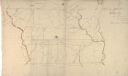
| Date: | 1832 |
|---|---|
| Description: | Hand-drawn map in two parts of the route of Governor J.D. Doty. Probably made by Doty in 1832 as a result of his travels with Alexander J. Center. |

| Date: | 1790 |
|---|---|
| Description: | Map of the region surrounding Dayton, Ohio showing rivers and other settlements, with a table of distances from Cincinnati to Dayton and to points outside ... |

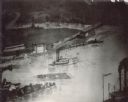
| Date: | |
|---|---|
| Description: | A Menominee Indian Village on Wolf River. There are dwellings on the shore and many people in canoes are on the river. |
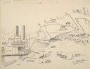
| Date: | 1870 |
|---|---|
| Description: | Sketch of the Fox River, a train, the mill, a warehouse, and a steamboat. |
| Date: | 05 02 1849 |
|---|---|
| Description: | The ferry landing in Weston, Missouri; Sketched by Wilkins on his 151-day journey from Missouri to California on the Overland Trail (also known as the Oreg... |
| Date: | 05 17 1849 |
|---|---|
| Description: | The ferry at Nodaway, Missouri; Sketched by Wilkins on his 151-day journey from Missouri to California on the Overland Trail (also known as the Oregon Trai... |
| Date: | 05 17 1849 |
|---|---|
| Description: | The Mill in Nodaway, Missouri; Sketched by Wilkins on his 151-day journey from Missouri to California on the Overland Trail (also known as the Oregon Trail... |
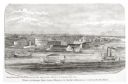
| Date: | |
|---|---|
| Description: | View of a fort with fortified walls and a flag flying from the fort. A river runs on the right of the image. A boat with sails floats on the river. Sold... |

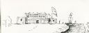
| Date: | 1851 |
|---|---|
| Description: | Several men rowing in a boat near Fort Howard that has an American Flag, barracks, and various related military buildings enclosed behind a wall. |
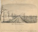
| Date: | 1876 |
|---|---|
| Description: | View looking southeast over river from Elmore and Kelly's Elevator. |
| Date: | 03 13 1862 |
|---|---|
| Description: | View down railroad tracks of the gunboat "Cinncinati" guarding Union approaches to Cairo on the Ohio River. |

| Date: | 1853 |
|---|---|
| Description: | Farwell's Mill on the Yahara River at Lake Mendota. |

| Date: | 1830 |
|---|---|
| Description: | Fort Winnebago from an original drawing by Jefferson Davis. |
| Date: | |
|---|---|
| Description: | Log raft and paddle steamer on the mouth of the Black River. On the banks of the river, there are buildings of a town visible. |
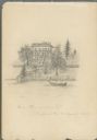
| Date: | 08 31 1885 |
|---|---|
| Description: | Pencil on paper drawing of large house on hill above river, with rowboat and boathouse. The house has three stories, four chimneys, mansard roof, and long... |
| Date: | 1869 |
|---|---|
| Description: | Hand-drawn map of York County, South Carolina. |
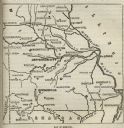
| Date: | |
|---|---|
| Description: | Map of Missouri with major cities, rivers, and railroads marked. |

| Date: | 1906 |
|---|---|
| Description: | Topographical map of Turville Point and lands to the South to Nine Springs Creek. |
If you didn't find the material you searched for, our Library Reference Staff can help.
Call our reference desk at 608-264-6535 or email us at: