Filter: Categories of Wisconsin Historical Images
Filter: FORMAT_TYPE of drawings
Filter: Subject of hills
Filter: Categories of Wisconsin Historical Images
Filter: FORMAT_TYPE of drawings
Filter: Subject of hills

| Date: | 1834 |
|---|---|
| Description: | Peck-a-ton-oka (Pecatonica River) with Rodolf farm in the background. |

| Date: | 1852 |
|---|---|
| Description: | Pencil drawing of Madison landscape as seen from University Hill. The main street in the center is State Street, and the building with Greek columns in the... |
| Date: | 1852 |
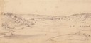
|---|---|
| Description: | Pencil drawing of Black Earth Valley. Gentle lightly tree-covered hills frame the center grassy valley. Two farmhouses are sitting at the base of hills on ... |
| Date: | 10 03 1862 |
|---|---|
| Description: | "Combined Confederate attack upon [Batteries] Robinette and Davis the attack on Battery Robinette being defeated and that on Davis resulting in the defeat ... |
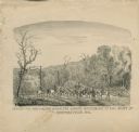
| Date: | |
|---|---|
| Description: | "Conveying Provisions over the Ozark Mountains to the Army at Springfield, MO." Men on horseback are riding along a trail carrying supplies. |

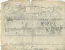
| Date: | 1849 |
|---|---|
| Description: | Pencil sketch of a cross-section of the Dells of the Wisconsin River. People are in a row boat in the center. Caption at bottom: "The Dells — Wisconsin Riv... |

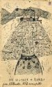
| Date: | 1900 |
|---|---|
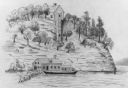
| Description: | Poem and drawing of the Walker Castle, entitled "The Deserted Castle." |
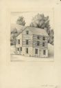
| Date: | 1946 |
|---|---|
| Description: | Pencil drawing (graphite and ink?) of Polperro House, at the Pendarvis State Historical Site in Mineral Point. Features a side gable entrance and a log fra... |
| Date: | 1903 |
|---|---|
| Description: | Drawing of a steamboat pulling a raft of cut boards. |
| Date: | 1903 |
|---|---|
| Description: | Drawing of the "Rambo" and "Musser" transporting a log raft on the Mississippi River. |

| Date: | |
|---|---|
| Description: | A hand-drawn map including the location of Daniel Boone's home and two forts, northeast of Lexington, Kentucky. |
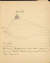
| Date: | 08 1852 |
|---|---|
| Description: | Pencil drawing of Rattlesnake Bluff and the town of Arena from a distance across a plain. A row of buildings runs along the foot of the gently rolling hill... |
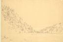
| Date: | 1852 |
|---|---|
| Description: | Devil's Lake from shore flanked by steep tree-covered hillsides. A small solitary rowboat floats near the distant shore. |
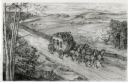
| Date: | 1948 |
|---|---|
| Description: | Drawing of a Madison to Prairie du Chien stage coach in 1848. The coach is driven by two men and drawn by four horses as it passes a farm field separated f... |

| Date: | 1947 |
|---|---|
| Description: | An ink on paper, hand-drawn map of Jefferson County, Wisconsin, that identifies named hills, other points of interest, and the Lake Mills moraine system in... |

| Date: | 1864 |
|---|---|
| Description: | This map is pen and watercolor on paper and shows profile and geological formation of Blue Mound and location of Arnold’s Hotel and Brigham Lead Mines. |
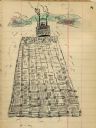
| Date: | 1897 |
|---|---|
| Description: | A pencil sketch of Butte des Morts, also called Hill of the Dead. There is a small building at the top of the hill. |

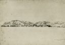
| Date: | 1905 |
|---|---|
| Description: | A very simple line drawing of the appearance of Butte des Morts from the east. |

| Date: | 1905 |
|---|---|
| Description: | A simple line sketch of the appearance of Butte des Morts from the south. |
If you didn't find the material you searched for, our Library Reference Staff can help.
Call our reference desk at 608-264-6535 or email us at: