Filter: Categories of Wisconsin Historical Images
Filter: FORMAT_TYPE of drawings
Filter: Subject of formations (geology)
Filter: Categories of Wisconsin Historical Images
Filter: FORMAT_TYPE of drawings
Filter: Subject of formations (geology)

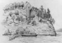
| Date: | 1872 |
|---|---|
| Description: | The sidewheel packet, Red Wing, in the Mississippi River near Queen's Bluff below Trempealeau, Wisconsin. |
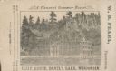
| Date: | |
|---|---|
| Description: | View of the Cliff House on the lake, with pine trees surrounding the property, and a cliff behind the building. |
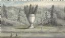
| Date: | |
|---|---|
| Description: | Artists depiction of a natural rock formation called "The Urn," which is 17 feet tall with another 10 feet of trees growing on top of the formation. |

| Date: | 1849 |
|---|---|
| Description: | Pencil sketch of a cross-section of the Dells of the Wisconsin River. People are in a row boat in the center. Caption at bottom: "The Dells — Wisconsin Riv... |
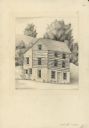
| Date: | 1946 |
|---|---|
| Description: | Pencil drawing (graphite and ink?) of Polperro House, at the Pendarvis State Historical Site in Mineral Point. Features a side gable entrance and a log fra... |

| Date: | |
|---|---|
| Description: | A hand-drawn Geological map of the Upper Peninsula of Michigan, showing the counties and streams of that area. The map also identifies the location of the... |

| Date: | 1866 |
|---|---|
| Description: | This manuscript map by Increase Lapham shows the Dells of the Wisconsin River, from Stand Rock and Witches Gulch at the north to a point approximately one ... |
| Date: | 06 08 1908 |
|---|---|
| Description: | Pen-and-ink on paper. Shows vicinity of Washburn Observatory and University Hall at the University of Wisconsin-Madison. Relief shown by contours and spot ... |

| Date: | 12 22 1830 |
|---|---|
| Description: | Increase Lapham's drawing of the geological profile between the Sandusky plains and Portsmouth, Ohio. |

| Date: | 1902 |
|---|---|
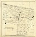
| Description: | This map is watercolor and pen on paper and relief shown by contours. The map reads: "Contour interval 10 feet." Shown on the map are geological features a... |

| Date: | 09 01 1856 |
|---|---|
| Description: | This map is pen-and-ink and shows farm lots, other lots of land sectioned by acres, bluffs, and a coulee. Also included are notations in pencil and blue in... |
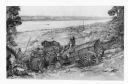
| Date: | 1948 |
|---|---|
| Description: | A pencil drawing of two men descending a bluff with oxen and a wagon to Winona, Minnesota. There is a church in the town below and the Mississippi River is... |

| Date: | |
|---|---|
| Description: | Colored ink drawing on paper of a red metal lantern on a stone wall at The House on the Rock. A denuded tree is on the left, on the face of Deep Shelter Ro... |
If you didn't find the material you searched for, our Library Reference Staff can help.
Call our reference desk at 608-264-6535 or email us at: