 Filter: Categories of Wisconsin Historical Images
Filter: FORMAT_TYPE of drawings
Filter: Subject of farms
Filter: Categories of Wisconsin Historical Images
Filter: FORMAT_TYPE of drawings
Filter: Subject of farms

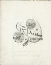
| Date: | 1833 |
|---|---|
| Description: | Township/section map showing Rodolf land and nearby neighbors. |

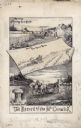
| Date: | 1834 |
|---|---|
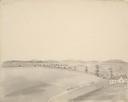
| Description: | Peck-a-ton-oka (Pecatonica River) with Rodolf farm in the background. |
| Date: | 05 1849 |
|---|---|
| Description: | A farm in Missouri with one wagon visible. Sketched by Wilkins on his 151-day journey from Missouri to California on the Overland Trail (also known as the ... |
| Date: | 05 1849 |
|---|---|
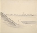
| Description: | The bottom lands and a farm in Missouri; Sketched by Wilkins on his 151-day journey from Missouri to California on the Overland Trail (also known as the Or... |
| Date: | |
|---|---|
| Description: | Home of Notorious Rebel — E.L. Newsome (located in New Madrid, Missouri). There is a farmstead with a man and woman in the foreground, a fence in the middl... |
| Date: | |
|---|---|
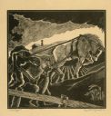
| Description: | Man working a horse-pulled plow, with a young boy walking at his side. |
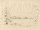
| Date: | 1852 |
|---|---|
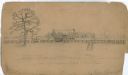
| Description: | Rural landscape with farm buildings seen from across a field and framed by trees. |
| Date: | 1884 |
|---|---|
| Description: | Original pen and ink drawing of an illustration used in a McCormick Company advertising catalog. Includes illustrations of a farmer using a horse-drawn gra... |
| Date: | 1890 |
|---|---|
| Description: | Original pen and ink drawing of an illustration for a McCormick Company advertising catalog. Includes illustrations of McCormick's "first" reaper and McCor... |
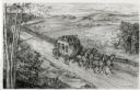
| Date: | 1948 |
|---|---|
| Description: | Drawing of a Madison to Prairie du Chien stage coach in 1848. The coach is driven by two men and drawn by four horses as it passes a farm field separated f... |

| Date: | 1882 |
|---|---|
| Description: | This manuscript map from 1882 shows land use and land for sale in a portion of the Town of Pewaukee, Waukesha County, Wisconsin. Woods, marshland, springs,... |

| Date: | 1879 |
|---|---|
| Description: | This hand-colored profile shows the depth and the fall of an approximately 14 mile long stretch of the Beaver Dam and Crawfish rivers in the towns of Lowel... |

| Date: | 1855 |
|---|---|
| Description: | This map is ink, pencil, and color on paper and shows property owners, a cemetery, farms, hotels, roads, a dike and on the back are additional notes. Notes... |

| Date: | 09 01 1856 |
|---|---|
| Description: | This map is pen-and-ink and shows farm lots, other lots of land sectioned by acres, bluffs, and a coulee. Also included are notations in pencil and blue in... |
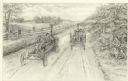
| Date: | 1948 |
|---|---|
| Description: | Pencil drawing depicting the first automobile race held in Wisconsin. The two vehicles each carry two men on a rural road. A handful of spectators, includ... |
If you didn't find the material you searched for, our Library Reference Staff can help.
Call our reference desk at 608-264-6535 or email us at: