Filter: Categories of Wisconsin Historical Images
Filter: FORMAT_TYPE of drawings
Filter: Subject of cities and towns
Filter: Year of 1800-1899
Filter: Categories of Wisconsin Historical Images
Filter: FORMAT_TYPE of drawings
Filter: Subject of cities and towns
Filter: Year of 1800-1899

| Date: | 06 24 1849 |
|---|---|
| Description: | Original wash drawing of Fort Laramie, Wyoming (actually Fort John; see note below). Sketched by Wilkins on his 151-day journey from Missouri to California... |

| Date: | 1851 |
|---|---|
| Description: | Plat map of the Town of Madison (Township 7N, Range 9E), from Volume 4, Federal Survey Plat Books. |

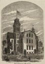
| Date: | 1855 |
|---|---|
| Description: | Detail from a lithograph vignette on a Map of the City of Madison of the third Wisconsin State Capitol, the first Capitol in Madison. |

| Date: | 1832 |
|---|---|
| Description: | Hand-drawn map in two parts of the route of Governor J.D. Doty. Probably made by Doty in 1832 as a result of his travels with Alexander J. Center. |

| Date: | 1852 |
|---|---|
| Description: | Pencil drawing of Madison landscape as seen from University Hill. The main street in the center is State Street, and the building with Greek columns in the... |

| Date: | 1852 |
|---|---|
| Description: | Pencil drawing of view overlooking Madison. The sketch looks down North Hamilton Street from the capitol. Rutted, irregular streets and frame houses mark ... |
| Date: | 05 04 1886 |
|---|---|
| Description: | Photograph of an artistic rendering of a rally held at Haymarket Square on May 4, 1886, before the explosion of the bomb. Haymarket Square is at the Inters... |

| Date: | 1840 |
|---|---|
| Description: | A hand-drawn plat map of Mineral Point, Wisconsin showing street layout and location of buildings. |

| Date: | 08 24 1876 |
|---|---|
| Description: | Hand-drawn plan of the battleground of Huycks. |

| Date: | 03 26 1876 |
|---|---|
| Description: | Hand-drawn map showing the place of Hook's defeat in York County in South Carolina. |

| Date: | 03 30 1835 |
|---|---|
| Description: | Map of township # 7N, range no. 10 east, 4th meridian, including Third Lake. |
| Date: | 1838 |
|---|---|
| Description: | Pencil sketch of a building owned by the Rodolf family along a commercial street. |
| Date: | 1838 |
|---|---|
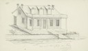
| Description: | Pencil sketch of a stone house with a porch the full length of the dwelling, supported by 6 columns. |
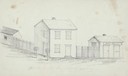
| Date: | 1838 |
|---|---|
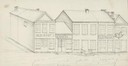
| Description: | Pencil sketch of buildings, including the Post Office. |
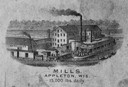
| Date: | 1870 |
|---|---|
| Description: | Sketch of the Fox River, a train, the mill, a warehouse, and a steamboat. |
| Date: | 1869 |
|---|---|
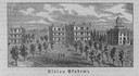
| Description: | View of the Berlin High School, with children playing and people walking in the foreground. |
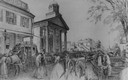
| Date: | 1859 |
|---|---|
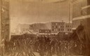
| Description: | City Hall in the background of a bustling street, with pedestrians, horses, carriages, and wagons. A stagecoach is parked across the street on the left. |
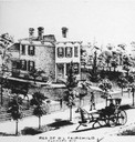
| Date: | 1873 |
|---|---|
| Description: | D.L. Fairchild residence from the street, with a stagecoach and pedestrian in the foreground. |
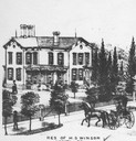
| Date: | 1873 |
|---|---|
| Description: | H.S. Winsor residence, with a stagecoach in the foreground. |
If you didn't find the material you searched for, our Library Reference Staff can help.
Call our reference desk at 608-264-6535 or email us at: