 Filter: Categories of Wisconsin Historical Images
Filter: FORMAT_TYPE of drawings
Filter: Subject of cities and towns
Filter: Community of Madison
Filter: Categories of Wisconsin Historical Images
Filter: FORMAT_TYPE of drawings
Filter: Subject of cities and towns
Filter: Community of Madison

| Date: | 1851 |
|---|---|
| Description: | Plat map of the Town of Madison (Township 7N, Range 9E), from Volume 4, Federal Survey Plat Books. |

| Date: | 1855 |
|---|---|
| Description: | Detail from a lithograph vignette on a Map of the City of Madison of the third Wisconsin State Capitol, the first Capitol in Madison. |

| Date: | 1832 |
|---|---|
| Description: | Hand-drawn map in two parts of the route of Governor J.D. Doty. Probably made by Doty in 1832 as a result of his travels with Alexander J. Center. |

| Date: | 1852 |
|---|---|
| Description: | Pencil drawing of Madison landscape as seen from University Hill. The main street in the center is State Street, and the building with Greek columns in the... |

| Date: | 1852 |
|---|---|
| Description: | Pencil drawing of view overlooking Madison. The sketch looks down North Hamilton Street from the capitol. Rutted, irregular streets and frame houses mark ... |
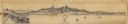
| Date: | |
|---|---|
| Description: | Panoramic view from the south end of Lake Monona, looking north to the isthmus, with the 3rd Wisconsin State Capitol in the center, and St. Raphael's Cathe... |
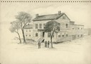
| Date: | 1860 |
|---|---|
| Description: | A drawing of the American House, 1 North Pinckney Street. It burned down in a fire in 1868. |
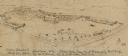
| Date: | 05 20 1864 |
|---|---|
| Description: | A sketch of Camp Randall made from the top of University Building, May 20, 1864, by W.F. Brown of the 40th Wisconsin Volunteer Infantry Company B. A small... |

| Date: | 1853 |
|---|---|
| Description: | Farwell's Mill on the Yahara River at Lake Mendota. |

| Date: | 07 01 1836 |
|---|---|
| Description: | Original plat map of the town of Madison on the four lakes. |

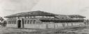
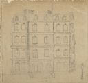
| Date: | 1890 |
|---|---|
| Description: | Benjamin Walker Castle, 1862-1893 in the 900 block of East Gorham Street. |
| Date: | 1909 |
|---|---|
| Description: | Architectural drawing. Caption reads: "Market House for the City of Madison". Robert L. Wright, Milwaukee, architect. |
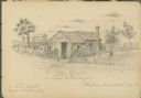
| Date: | 08 28 1885 |
|---|---|
| Description: | Sketch of the shack from which Benedict Goldenberger sold cider vinegar. Possibly on Murray Street. |
| Date: | |
|---|---|
| Description: | A drawing of the old Post Office on the corner of Wisconsin Avenue and Mifflin Street. |
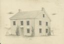
| Date: | 1946 |
|---|---|
| Description: | Pencil drawing of the Spring Inn, located at 3706 Nakoma Road. |

| Date: | 1982 |
|---|---|
| Description: | An illustration of The Sacred Feather, a shop that sells hats and leather goods, located at 417 State Street. |

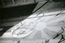
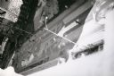
| Date: | 1974 |
|---|---|
| Description: | A view looking down from the Wisconsin State Historical Society building to artwork on the cement of State Street Mall. These paintings on the 800 and 900 ... |
| Date: | 1974 |
|---|---|
| Description: | A view looking down from the Wisconsin State Historical Society building to artwork on the cement of State Street Mall. These paintings on the 800 and 900 ... |
| Date: | 1974 |
|---|---|
| Description: | A view looking down from the Wisconsin State Historical Society building to artwork on the cement of State Street Mall. These paintings on the 800 and 900 ... |
If you didn't find the material you searched for, our Library Reference Staff can help.
Call our reference desk at 608-264-6535 or email us at:
