 Filter: Categories of Wisconsin Historical Images
Filter: FORMAT_TYPE of drawings
Filter: Subject of canals
Filter: Categories of Wisconsin Historical Images
Filter: FORMAT_TYPE of drawings
Filter: Subject of canals
| Date: | 1856 |
|---|---|
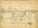
| Description: | An original illustration of the lock at Rexford Flats. |
| Date: | 1903 |
|---|---|
| Description: | Lock and dam system on a canal along the Mississippi River. |

| Date: | 1837 |
|---|---|
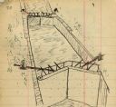
| Description: | A pen and ink on tracing paper, hand-drawn and colored map the proposed route of the Milwaukee and Rock River Canal, ranging from the Rock River in the wes... |

| Date: | 1881 |
|---|---|
| Description: | Ink, watercolor, and pencil on paper. Top of the map reads: "NORTHERN OUTLET MENASHA MEANDER LINES Scale 132ft 1 INCH Var S.E. Survey Completed Spet. 23 18... |
| Date: | 1827 |
|---|---|
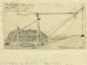
| Description: | Increase Lapham's drawing of a rig designed by Mr. Orange Dibble for removing rocks and other large debris from deep canal cuts. |

| Date: | 1910 |
|---|---|
| Description: | This ink on paper blue line print base map consists of eight separate pieces and shows city limits, The Milwaukee Electric Railroad & Light Company lines, ... |

| Date: | 12 1886 |
|---|---|
| Description: | This map is ink and pen on tracing cloth and shows land ownership by name, canals, local streets, section lines, and original low water lines in blue. The ... |
If you didn't find the material you searched for, our Library Reference Staff can help.
Call our reference desk at 608-264-6535 or email us at: