Filter: Categories of Wisconsin Historical Images
Filter: FORMAT_TYPE of drawings
Filter: Subject of bridges
Filter: Categories of Wisconsin Historical Images
Filter: FORMAT_TYPE of drawings
Filter: Subject of bridges
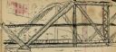
| Date: | 01 09 1940 |
|---|---|
| Description: | Blueprint design for a suspension footbridge for Copper Falls State Park. |

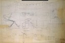
| Date: | 02 14 1939 |
|---|---|
| Description: | Deatiled blueprint (pg 2) for the suspension footbridge in Copper Falls State Park. |
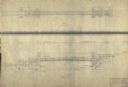
| Date: | 12 14 1939 |
|---|---|
| Description: | Page 1 of detailed blueprints for the suspension footbridge in Copper Falls State Park. |
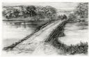
| Date: | 1948 |
|---|---|
| Description: | Drawing depicting a horse-drawn carriage crossing a stone and log causeway built across a river. |

| Date: | 1800 |
|---|---|
| Description: | This pen and ink drawing with watercolor shows the course of the Black River from Rock Creek, near Greenwood in Clark County, Wisconsin, to its confluence ... |

| Date: | 1872 |
|---|---|
| Description: | This map is pencil, ink, and watercolor on paper. Shown on the map is the elevation and profile of La Crescent Bottoms, Mt. Vernon Street line, 13th Street... |

| Date: | 1900 |
|---|---|
| Description: | The map is watercolor, pencil, and ink on tracing cloth and shows plats of both cities, local streets, railroads, mills, township divisions, bridges, and p... |
| Date: | 1857 |
|---|---|
| Description: | This manuscript map is ink and watercolor on tracing cloth and shows bridges, lots, and streets. Some of the lots are in pink ink. The left of the map incl... |

| Date: | 1876 |
|---|---|
| Description: | This map is ink on tracing cloth and shows the Black River, French Slough, Little French Slough, the southern portion of North La Crosse, the Milwaukee & S... |

| Date: | |
|---|---|
| Description: | A man wearing dark clothing and a cap is in mid-air, jumping off a bridge. He is holding something in his arms. Above him is the curved wall of the bridge,... |
| Date: | 1906 |
|---|---|
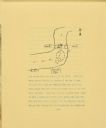
| Description: | A drawing of The Gang's camp on a hill next to Eagle River. The drawing includes the river, a road, and a bridge. Arrows drawn on the river show the direct... |

| Date: | 1875 |
|---|---|
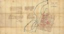
| Description: | The City of Fort Howard, Brown County, Wisconsin. Compiled from the records and drawn by F.E. Predergast, of De Pere. |
If you didn't find the material you searched for, our Library Reference Staff can help.
Call our reference desk at 608-264-6535 or email us at: