Filter: Categories of Wisconsin Historical Images
Filter: FORMAT_TYPE of drawings
Filter: Subject of architecture
Filter: Categories of Wisconsin Historical Images
Filter: FORMAT_TYPE of drawings
Filter: Subject of architecture

| Date: | 1953 |
|---|---|
| Description: | Colored pencil on brownline drawing of the entrance to the R.J. Buellesbach residence designed and drawn by architect John Randal McDonald. |
| Date: | 1958 |
|---|---|
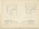
| Description: | Pencil on velum drawing of the Charles Murphy residence showing the floor plan and East and West elevations designed and drawn by architect John Randal McD... |
| Date: | 1957 |
|---|---|
| Description: | Pencil on vellum drawing of the exterior of the Joseph Hafen residence designed and drawn by architect John Randal McDonald. |
| Date: | 08 1948 |
|---|---|
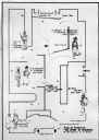
| Description: | Floor plan of the Wisconsin Historical Society's "Story of Wisconsin" exhibit at the Wisconsin Centennial Exposition. |
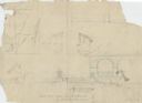
| Date: | 1938 |
|---|---|
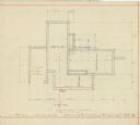
| Description: | Footing plan for the Mac Wilkie house drawn by the architect William Kaeser. The house was planned for the Sunset Village neighborhood. |

| Date: | 1938 |
|---|---|
| Description: | Colored drawing of the front elevation for the Mac Wilkie house drawn by the architect William Kaeser. The house was planned for the Sunset Village neighbo... |

| Date: | 1938 |
|---|---|
| Description: | Black and white drawing of two elevations for the Mac Wilkie house drawn by the architect William Kaeser. The house was planned for the Sunset Village neig... |
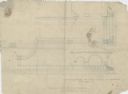
| Date: | 1948 |
|---|---|
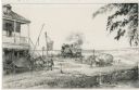
| Description: | Drawing of a passenger train approaching a small town where two teams of horses on a plank road appear to be startled by the noise of the locomotive. One t... |

| Date: | |
|---|---|
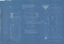
| Description: | Blueprint of the formal garden for Stanley McCormick's Riven Rock estate at El Montecito, Santa Barbara, California. The blueprint was created by Shepley, ... |

| Date: | 1900 |
|---|---|
| Description: | Blueprint of the stone seat, outside elevation of Gate "Y," rear of fountain at end of basin, and elevation of Gate "Z" for Stanley McCormick's Riven Rock ... |

| Date: | 1900 |
|---|---|
| Description: | Blueprint showing the elevation of Gate "X" for Stanley McCormick's Riven Rock estate at El Montecito, Santa Barbara, California. The blueprint shows a vie... |

| Date: | 1897 |
|---|---|
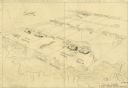
| Description: | Topographical map of Stanley McCormick's Riven Rock estate in El Montecito, Santa Barbara County, California. The map is identified as a map of a survey co... |
| Date: | |
|---|---|
| Description: | A blueprint showing the second floor balcony outside of the linen room of Stanley McCormick's Riven Rock estate in El Montecito, Santa Barbara County, Cali... |
| Date: | 1900 |
|---|---|
| Description: | Blueprint showing the mantles at Stanley McCormick's Riven Rock estate in El Montecito, Santa Barbara County, California. The architectural firm is identif... |

| Date: | 1899 |
|---|---|
| Description: | Topographical map showing ridges, water courses, boundary lines, and trails and roads near the Stanley McCormick's Riven Rock estate in El Montecito, Santa... |

| Date: | 1899 |
|---|---|
| Description: | Map of the Santa Barbara Channel California area showing property boundaries and some geographical features. The Riven Rock Estate has been outlined in yel... |

| Date: | |
|---|---|
| Description: | Blueprint of the formal garden for Stanley McCormick's Riven Rock estate at El Montecito, Santa Barbara County, California. The blueprint shows different v... |
| Date: | |
|---|---|
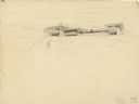
| Description: | A drawing of the south elevation of the east portion of a terrace at the Riven Rock McCormick Family Estate in El Montecito, Santa Barbara County, Californ... |
| Date: | 1899 |
|---|---|
| Description: | Architectural drawing of the East Elevation of the terrace at Riven Rock, Stanley McCormick's estate in El Montecito, Santa Barbara County, California. The... |
If you didn't find the material you searched for, our Library Reference Staff can help.
Call our reference desk at 608-264-6535 or email us at: