Filter: Categories of Wisconsin Historical Images
Filter: FORMAT_TYPE of drawings
Filter: Reproduction Rights of For Sale
Filter: Categories of Wisconsin Historical Images
Filter: FORMAT_TYPE of drawings
Filter: Reproduction Rights of For Sale
| Date: | |
|---|---|
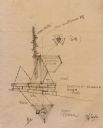
| Description: | Sketch for Taliesin West private garden court totem pole, drawn by Frank Lloyd Wright. The sketch includes elevations, a plan, and details and are drawn on... |
| Date: | |
|---|---|
| Description: | Pencil sketch of an elevation and the site plan, drawn by Frank Lloyd Wright, of the First Unitarian Society Meeting House sign. |
| Date: | |
|---|---|
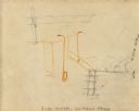
| Description: | Pencil sketch of the plan and elevation drawn by Frank Lloyd Wright, of the foyer fireplace for the First Unitarian Society Meeting House. |
| Date: | |
|---|---|
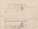
| Description: | Pencil sketch for trusses drawn by Frank Lloyd Wright for the First Unitarian Society Meeting House. The sketch was drawn on the back of a photograph of th... |

| Date: | 08 24 1876 |
|---|---|
| Description: | Hand-drawn plan of the battleground of Huycks. |

| Date: | 03 26 1876 |
|---|---|
| Description: | Hand-drawn map showing the place of Hook's defeat in York County in South Carolina. |
| Date: | |
|---|---|
| Description: | Caricature of "Cyrusie" McCormick operating a horse-drawn McCormick reaper. |

| Date: | |
|---|---|
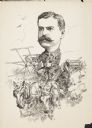
| Description: | Caricature of Alexander Legge. Legge was president of International Harvester Company from 1922 to 1929. He was vice chairman of the War Industries Board ... |

| Date: | |
|---|---|
| Description: | A Menominee Indian Village on Wolf River. There are dwellings on the shore and many people in canoes are on the river. |
| Date: | 1856 |
|---|---|
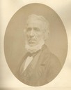
| Description: | Quarter-length oval portrait of Ebenezer Brigham, founder of the first major community in the Blue Mounds of Wisconsin, which included a mine, frontier inn... |

| Date: | |
|---|---|
| Description: | Hand-colored drawing of President Abraham Lincoln. This image is one of several on a page from the Grant family bible. |
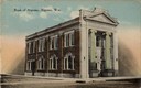
| Date: | |
|---|---|
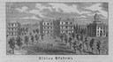
| Description: | View across street toward the bank. Caption reads: "Bank of Algoma, Algoma, Wis." |

| Date: | 03 30 1835 |
|---|---|
| Description: | Map of township # 7N, range no. 10 east, 4th meridian, including Third Lake. |

| Date: | 1850 |
|---|---|
| Description: | Lithograph of a map drawn to indicate a mine on land owned by Mineral Point Mining Co. in the lead region of southwestern Wisconsin. |
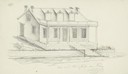
| Date: | 1838 |
|---|---|
| Description: | Pencil sketch of a building owned by the Rodolf family along a commercial street. |
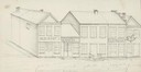
| Date: | 1838 |
|---|---|
| Description: | Pencil sketch of a stone house with a porch the full length of the dwelling, supported by 6 columns. |
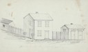
| Date: | 1838 |
|---|---|
| Description: | Pencil sketch of buildings, including the Post Office. |

| Date: | |
|---|---|
| Description: | Rendering of a Thordarson Electical Manufacturing Company product. Chester Thordarson was a Chicago inventor and manufacturer of electical apparatus, famo... |
If you didn't find the material you searched for, our Library Reference Staff can help.
Call our reference desk at 608-264-6535 or email us at: