 Filter: Categories of Wisconsin Historical Images
Filter: FORMAT_TYPE of drawings
Filter: County of Rock
Filter: Categories of Wisconsin Historical Images
Filter: FORMAT_TYPE of drawings
Filter: County of Rock
| Date: | 07 15 1927 |
|---|---|
| Description: | Survey and development plan of the home grounds area of Mr. and Mrs. George S. Parker, drawn in red, black, and brown ink. |
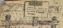
| Date: | 1903 |
|---|---|
| Description: | Sign posted on a fence announcing a lost camera near the town of Prairie du Sac and requesting its return to Herbert Fowler. |

| Date: | |
|---|---|
| Description: | An ink and water color on paper, hand-drawn map showing the section divisions in the southern half of the Janesville Township (Township 3 North, Range 12 E... |

| Date: | 1800 |
|---|---|
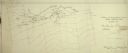
| Description: | This map on two sheets shows a group of ancient mounds near the southeast corner of the city of Beloit and a group of ancient mounds north of Rockton Stati... |

| Date: | 1836 |
|---|---|
| Description: | This map is ink on tracing paper and shows block numbers, streets, lot numbers of block no. 6, and a public square in Newburgh, a paper city (a city planne... |
If you didn't find the material you searched for, our Library Reference Staff can help.
Call our reference desk at 608-264-6535 or email us at: