 Filter: Categories of Wisconsin Historical Images
Filter: FORMAT_TYPE of drawings
Filter: County of Dunn
Filter: Categories of Wisconsin Historical Images
Filter: FORMAT_TYPE of drawings
Filter: County of Dunn
| Date: | 1880 |
|---|---|
| Description: | This plat of Vanceburg Cemetery, Town of Sheridan, Dunn County, Wisconsin, likely dates from the 1880s and "is intended for the correction of names of peop... |
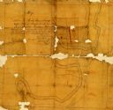
| Date: | 1860 |
|---|---|
| Description: | Pencil and ink on paper. "Showing the government meander line on the left bank of Rock River and the actual course of Rock River together with the several ... |

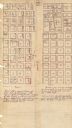
| Date: | 1859 |
|---|---|
| Description: | This plat map is pen on paper and shows numbered blocks and lots, local streets, and section lines. Also included is text on survey certifications. |

| Date: | 1859 |
|---|---|
| Description: | This plat map is pen on paper and shows numbered blocks and lots, local streets, and section lines. Also included is text on survey certifications. The top... |
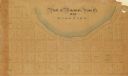
| Date: | |
|---|---|
| Description: | This plat map is pen, pencil, and watercolor on paper and shows numbered blocks and lots, local streets, section lines, the public square, Mill pond, and l... |
If you didn't find the material you searched for, our Library Reference Staff can help.
Call our reference desk at 608-264-6535 or email us at: