Filter: Categories of Wisconsin Historical Images
Filter: FORMAT_TYPE of drawings
Filter: County of Dane
Filter: Year of 1800-1899
Filter: Categories of Wisconsin Historical Images
Filter: FORMAT_TYPE of drawings
Filter: County of Dane
Filter: Year of 1800-1899
| Date: | 08 25 1885 |
|---|---|
| Description: | Gates of Heaven Synagogue. Designed by August Kutzbock. |
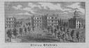
| Date: | 1856 |
|---|---|
| Description: | The Wisconsin State Capitol (the second State Capitol, the first in Madison). Illustration from the American Encyclopedia, Columbus, 1859. |

| Date: | 1851 |
|---|---|
| Description: | Plat map of the Town of Madison (Township 7N, Range 9E), from Volume 4, Federal Survey Plat Books. |

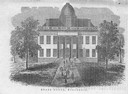
| Date: | 1855 |
|---|---|
| Description: | Detail from a lithograph vignette on a Map of the City of Madison of the third Wisconsin State Capitol, the first Capitol in Madison. |
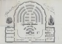
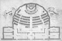
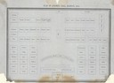
| Date: | 1874 |
|---|---|
| Description: | Seating chart for members of the Wisconsin Assembly as published in the 1874 Legislative Manual, the Wisconsin Blue Book. |

| Date: | 1832 |
|---|---|
| Description: | Hand-drawn map in two parts of the route of Governor J.D. Doty. Probably made by Doty in 1832 as a result of his travels with Alexander J. Center. |
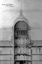
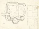
| Date: | 1857 |
|---|---|
| Description: | Section drawing of the rotunda of the third Wisconsin State Capitol (second in Madison) by Stephen V. Shipman. August Kutzbock and Samuel H. Donnel were th... |

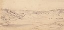
| Date: | 1852 |
|---|---|
| Description: | Pencil drawing of Madison landscape as seen from University Hill. The main street in the center is State Street, and the building with Greek columns in the... |

| Date: | 1852 |
|---|---|
| Description: | Pencil drawing of view overlooking Madison. The sketch looks down North Hamilton Street from the capitol. Rutted, irregular streets and frame houses mark ... |
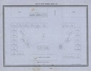
| Date: | 1860 |
|---|---|
| Description: | Floor plan and seating chart for the Assembly for their first meeting in the East Wing of new Wisconsin State Capitol building. After the completion of th... |
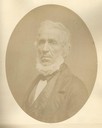
| Date: | 1856 |
|---|---|
| Description: | Quarter-length oval portrait of Ebenezer Brigham, founder of the first major community in the Blue Mounds of Wisconsin, which included a mine, frontier inn... |
| Date: | 1852 |
|---|---|
| Description: | Pencil drawing of Black Earth Valley. Gentle lightly tree-covered hills frame the center grassy valley. Two farmhouses are sitting at the base of hills on ... |
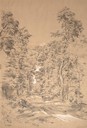
| Date: | 08 1852 |
|---|---|
| Description: | Pencil drawing of a dirt road through the woods with added white highlights. A horse-drawn wagon with two passengers moves down the road in the distance, ... |
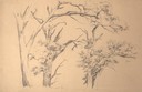
| Date: | 09 1852 |
|---|---|
| Description: | Pencil drawing of oak trees on in the oak savanna setting. The illustrated trees have dead branches but still sprout some live leaves. |
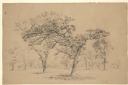
| Date: | 08 1852 |
|---|---|
| Description: | Pencil drawing of Bur Oaks in the oak savanna setting, one graceful detailed tree in the center foreground. |
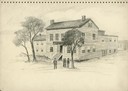
| Date: | 1860 |
|---|---|
| Description: | A drawing of the American House, 1 North Pinckney Street. It burned down in a fire in 1868. |
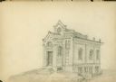
| Date: | 1859 |
|---|---|
| Description: | An original pencil sketch by banker and real estate developer Napoleon B. Van Slyke, possibly for his residence erected in 1859 at 510 North Carroll Street... |
| Date: | 1855 |
|---|---|
| Description: | Plan of the Senate Chamber for the second Wisconsin State Capitol (the first in Madison), showing the seating arrangement. |
| Date: | 1855 |
|---|---|
| Description: | Plan of the Assembly Hall in the second Wisconsin State Capitol showing the seating arrangement. |
If you didn't find the material you searched for, our Library Reference Staff can help.
Call our reference desk at 608-264-6535 or email us at: