 Filter: Categories of Wisconsin Historical Images
Filter: FORMAT_TYPE of drawings
Filter: County of Dane
Filter: Categories of Wisconsin Historical Images
Filter: FORMAT_TYPE of drawings
Filter: County of Dane

| Date: | 1930 |
|---|---|
| Description: | Logo submitted to the state of Wisconsin for trademark registration. "Jack Penewell's Original, Twin Six, Talking Steel Guitar." An image of a steel guitar... |
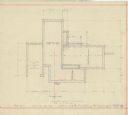
| Date: | 1938 |
|---|---|
| Description: | Footing plan for the Mac Wilkie house drawn by the architect William Kaeser. The house was planned for the Sunset Village neighborhood. |

| Date: | 1938 |
|---|---|
| Description: | Colored drawing of the front elevation for the Mac Wilkie house drawn by the architect William Kaeser. The house was planned for the Sunset Village neighbo... |

| Date: | 1938 |
|---|---|
| Description: | Black and white drawing of two elevations for the Mac Wilkie house drawn by the architect William Kaeser. The house was planned for the Sunset Village neig... |

| Date: | 1864 |
|---|---|
| Description: | This map is pen and watercolor on paper and shows profile and geological formation of Blue Mound and location of Arnold’s Hotel and Brigham Lead Mines. |

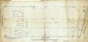
| Date: | 06 08 1960 |
|---|---|
| Description: | Blueprint plat of Sunset Hills sub-division. |

| Date: | 1880 |
|---|---|
| Description: | This map is pen-and-ink on paper. The map shows buildings, trees, and water and gas pipes, relief is shown by contours. The back of the map reads: "Univers... |
| Date: | 09 1886 |
|---|---|
| Description: | This map shows buildings with dimensions, as well as lot and block corners. Ink on tracing cloth. Oriented with north to the lower right. |

| Date: | 1906 |
|---|---|
| Description: | This map is pen-and-ink on paper. The relief is shown by contours and spot heights. "5’ contours." Includes area table. |
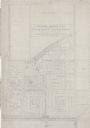
| Date: | 06 08 1908 |
|---|---|
| Description: | Pen-and-ink on paper. Shows vicinity of Washburn Observatory and University Hall at the University of Wisconsin-Madison. Relief shown by contours and spot ... |
| Date: | 1938 |
|---|---|
| Description: | Architectural drawing of the Sunset Village neighborhood on the West side of the city of Madison. The poster description reads: A proposed master plan for ... |

| Date: | 1857 |
|---|---|
| Description: | This map is ink and pencil on tracing paper. The map shows plats of a western section of Madison. The lakes are labeled "Fourth Lake", "Third Lake" and "La... |

| Date: | 1902 |
|---|---|
| Description: | This map is watercolor and pen on paper and relief shown by contours. The map reads: "Contour interval 10 feet." Shown on the map are geological features a... |
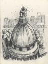
| Date: | |
|---|---|
| Description: | Drawing of the Wisconsin State Capitol building. Features the dome with the "Wisconsin" statue replaced by a seated beekeeper wearing protective clothing, ... |
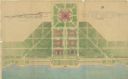
| Date: | 07 1939 |
|---|---|
| Description: | An architectural rendering of a proposed lakefront development plan. |

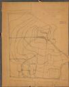
| Date: | |
|---|---|
| Description: | Detail from a drawing of a plan for the isthmus. |
| Date: | 04 1904 |
|---|---|
| Description: | This map is pen and pencil on paper and shows local streets, and the following University of Wisconsin-Madison buildings: the Main Hall, South Hall, North ... |

| Date: | 1910 |
|---|---|
| Description: | This maps is pen and pencil on tracing cloth and shows local streets, buildings, proposed and present branches of railroad track, and sewer and water lines... |

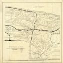
| Date: | 1969 |
|---|---|
| Description: | This map is pen and ink on paper and shows the location of churches, local streets, railroads, parks, Middleton, Shorewood Hills, Monona, Maple Bluff, McFa... |

| Date: | 1861 |
|---|---|
| Description: | Shaded drawings with size dimensions for plans of "Tents used in Civil War. U.S. Army Regulation Tents." Upper left, "18. ft diam, Gilbert Anderson Hub... |
If you didn't find the material you searched for, our Library Reference Staff can help.
Call our reference desk at 608-264-6535 or email us at: