 Filter: Categories of Wisconsin Historical Images
Filter: FORMAT_TYPE of drawings
Filter: Community of Mineral Point
Filter: Categories of Wisconsin Historical Images
Filter: FORMAT_TYPE of drawings
Filter: Community of Mineral Point

| Date: | 1840 |
|---|---|
| Description: | A hand-drawn plat map of Mineral Point, Wisconsin showing street layout and location of buildings. |

| Date: | 1850 |
|---|---|
| Description: | Lithograph of a map drawn to indicate a mine on land owned by Mineral Point Mining Co. in the lead region of southwestern Wisconsin. |
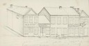
| Date: | 1838 |
|---|---|
| Description: | Pencil sketch of a building owned by the Rodolf family along a commercial street. |
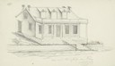
| Date: | 1838 |
|---|---|
| Description: | Pencil sketch of a stone house with a porch the full length of the dwelling, supported by 6 columns. |
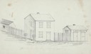
| Date: | 1838 |
|---|---|
| Description: | Pencil sketch of buildings, including the Post Office. |
| Date: | 1946 |
|---|---|
| Description: | Pencil drawing (graphite and ink?) of Polperro House, at the Pendarvis State Historical Site in Mineral Point. Features a side gable entrance and a log fra... |

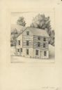
| Date: | 1946 |
|---|---|
| Description: | Pencil drawing of the Pendarvis and Trelawny Houses. Stone building with six over six windows on two levels, and three entrances. A stone wall runs along t... |

| Date: | 1856 |
|---|---|
| Description: | This map of Woodman's Addition in Mineral Point is pen-and-ink on paper. The map includes certifications signed by John B. Whitelaw (surveyor), Cyrus Woodm... |
If you didn't find the material you searched for, our Library Reference Staff can help.
Call our reference desk at 608-264-6535 or email us at: