 Filter: Categories of Wisconsin Historical Images
Filter: FORMAT_TYPE of drawings
Filter: Creator Name of Unknown
Filter: Categories of Wisconsin Historical Images
Filter: FORMAT_TYPE of drawings
Filter: Creator Name of Unknown

| Date: | |
|---|---|
| Description: | A hand-drawn map of Indian boundary lines in southwest Virginia. It also includes the Duck River and the Elk River. |

| Date: | |
|---|---|
| Description: | Charcoal drawing of a golden eagle perched on a barrel. Likely the wild golden eagle Andy Johnson, the mascot of the Forty-Ninth Wisconsin Civil War Infan... |

| Date: | 1881 |
|---|---|
| Description: | A black and silver, hand-drawn, pen and ink holiday card with an Asian theme. A woman and a young man are facing each other, and a dried flower and sprig o... |

| Date: | 1932 |
|---|---|
| Description: | Holiday card of a hobo in a jacket and hat seated in front of a campfire, warming his hands. His bundle of belongings is on a stick by his side. His footpr... |
| Date: | 1878 |
|---|---|
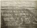
| Description: | Engraved view of a house surrounded by gardens, an evergreen shelter belt and ornamental hedges. |

| Date: | 1898 |
|---|---|
| Description: | Drawing of a burdock planted at the foundation of a building. |
| Date: | |
|---|---|
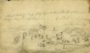
| Description: | A rough sketch of Camp Judas, the 12th Regiment's first bivouac under Colonel George E. Bryant. |

| Date: | 1941 |
|---|---|
| Description: | Hand-drawn, watercolor and ink, map of Lake Mendota. Locations and many small figures appear around the shore with explanations referring to Indian legends... |

| Date: | 1930 |
|---|---|
| Description: | Logo submitted to the state of Wisconsin for trademark registration. "Jack Penewell's Original, Twin Six, Talking Steel Guitar." An image of a steel guitar... |

| Date: | 1860 |
|---|---|
| Description: | A hand-drawn, ink on cloth map of southeastern Wisconsin that show roads and railroads that connect Chicago to Milwaukee and other towns in the southeaster... |
| Date: | 07 23 1940 |
|---|---|
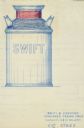
| Description: | Drawing submitted to the state of Wisconsin for trademark registration. Swift & Company standard cream cans illustration. The shoulders of the cans are pai... |
| Date: | 02 14 1935 |
|---|---|
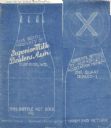
| Description: | Blueprint submitted to the State of Wisconsin for trademark registration from the Superior Milk Dealers Association. Features a drawing of the bottle and b... |

| Date: | 04 11 1935 |
|---|---|
| Description: | Drawing submitted to the state of Wisconsin for trademark registration. Button design with a drawing of a flower and the statement: "Certified W.S.S.A." |

| Date: | 04 26 1935 |
|---|---|
| Description: | Drawing submitted to the State of Wisconsin for trademark registration. The drawing includes the word "Progressive" in blue and white letters over the shap... |
| Date: | 06 12 1935 |
|---|---|
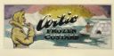
| Description: | Label submitted to the State of Wisconsin for trademark registration. Features an Eskimo in a yellow coat and hat eating an ice cream cone. In the backgrou... |

| Date: | 07 29 1935 |
|---|---|
| Description: | Label submitted to the State of Wisconsin for trademark registration. "Frigid Frozen Custard." Features two men, each driving a dog sled with teams of dogs... |
| Date: | 09 20 1943 |
|---|---|
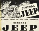
| Description: | Drawing submitted to the State of Wisconsin for trademark registration. "A Sturdy, Timely Toy For Your Youngster. General Jeep." Features a drawing of four... |
| Date: | |
|---|---|
| Description: | Hand-drawn map of the town of Cadiz, Wisconsin near the Illinois border showing plots of landownership. The map also includes one landmark of the Pecatonic... |

| Date: | 1832 |
|---|---|
| Description: | A hand-drawn map showing the survey of Township number 4, Range number 5, West Fourth Principal Meridian, which is parts of the present day towns of Glen H... |
If you didn't find the material you searched for, our Library Reference Staff can help.
Call our reference desk at 608-264-6535 or email us at:
