Filter: Categories of Wisconsin Historical Images
Filter: FORMAT_TYPE of drawings
Filter: Creator Name of Unknown
Filter: Subject of transportation
Filter: Categories of Wisconsin Historical Images
Filter: FORMAT_TYPE of drawings
Filter: Creator Name of Unknown
Filter: Subject of transportation
| Date: | 1856 |
|---|---|
| Description: | The Wisconsin State Capitol (the second State Capitol, the first in Madison). Illustration from the American Encyclopedia, Columbus, 1859. |

| Date: | 1872 |
|---|---|
| Description: | The sidewheel packet, Red Wing, in the Mississippi River near Queen's Bluff below Trempealeau, Wisconsin. |
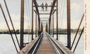
| Date: | |
|---|---|
| Description: | Colorized view depicting the Wisconsin Central Railroad bridge at Stevens Point, with several men standing on top of the bridge painting the structure. Cap... |
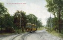
| Date: | 1911 |
|---|---|
| Description: | Colorized view of the railroad curve near Whitefish Bay resort. Caption reads: "The Curve near Whitefish Bay Resort." |
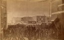
| Date: | 05 04 1886 |
|---|---|
| Description: | Photograph of an artistic rendering of a rally held at Haymarket Square on May 4, 1886, before the explosion of the bomb. Haymarket Square is at the Inters... |

| Date: | 1840 |
|---|---|
| Description: | A hand-drawn plat map of Mineral Point, Wisconsin showing street layout and location of buildings. |

| Date: | |
|---|---|
| Description: | A Menominee Indian Village on Wolf River. There are dwellings on the shore and many people in canoes are on the river. |
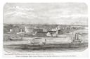
| Date: | 1870 |
|---|---|
| Description: | Sketch of the Fox River, a train, the mill, a warehouse, and a steamboat. |
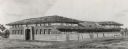
| Date: | |
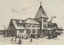
|---|---|
| Description: | Exterior of the Wisconsin Central Railroad Depot . |

| Date: | 1851 |
|---|---|
| Description: | Several men rowing in a boat near Fort Howard that has an American Flag, barracks, and various related military buildings enclosed behind a wall. |
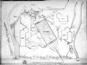
| Date: | 1957 |
|---|---|
| Description: | Plot plan for a proposed transportation museum. |
| Date: | 1876 |
|---|---|
| Description: | View looking southeast over river from Elmore and Kelly's Elevator. |
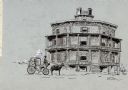
| Date: | 1885 |
|---|---|
| Description: | Drawing of the Octagon House with a horse and carriage in the foreground. |

| Date: | 1885 |
|---|---|
| Description: | Illustrated view of Superior, as well as Omaha, Kansas City, St. Paul, and Winnipeg. Caption reads: "Superior - The Last Possible Great Marine City in the ... |

| Date: | 07 01 1836 |
|---|---|
| Description: | Original plat map of the town of Madison on the four lakes. |
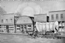
| Date: | 1858 |
|---|---|
| Description: | View on North Water Street, showing the building in which the Bank of Sparta was founded. A man is walking beside a oxen pulling a covered wagon. |
| Date: | 1909 |
|---|---|
| Description: | Architectural drawing. Caption reads: "Market House for the City of Madison". Robert L. Wright, Milwaukee, architect. |
If you didn't find the material you searched for, our Library Reference Staff can help.
Call our reference desk at 608-264-6535 or email us at: