 Filter: Categories of Wisconsin Historical Images
Filter: FORMAT_TYPE of drawings
Filter: Creator Name of Unknown
Filter: County of Milwaukee
Filter: Categories of Wisconsin Historical Images
Filter: FORMAT_TYPE of drawings
Filter: Creator Name of Unknown
Filter: County of Milwaukee
| Date: | 1911 |
|---|---|
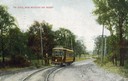
| Description: | Colorized view of the railroad curve near Whitefish Bay resort. Caption reads: "The Curve near Whitefish Bay Resort." |

| Date: | 08 1948 |
|---|---|
| Description: | This original, modernistic color design for a Wisconsin Dairyland Building at the Wisconsin State Fair included a pitcher pouring milk. It was constructed ... |
| Date: | 1923 |
|---|---|
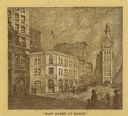
| Description: | East Water Street at Mason, looking at the Morris E. Fox & Co. building. |

| Date: | 04 11 1935 |
|---|---|
| Description: | Drawing submitted to the state of Wisconsin for trademark registration. Button design with a drawing of a flower and the statement: "Certified W.S.S.A." |

| Date: | 09 20 1943 |
|---|---|
| Description: | Drawing submitted to the State of Wisconsin for trademark registration. "A Sturdy, Timely Toy For Your Youngster. General Jeep." Features a drawing of four... |

| Date: | 1835 |
|---|---|
| Description: | This map is pen-and-ink on paper. The map shows landowners in "Milwalky" or present day Milwaukee. Includes "list of property offered to Mr. Walker". The m... |

| Date: | 06 1837 |
|---|---|
| Description: | Pen-and-ink on paper. Shows riverside property west of the Milwaukee River. Inscribed by several early Milwaukee settlers, including Henry W. Cleveland, Cy... |

| Date: | 1840 |
|---|---|
| Description: | Pen-and-ink on paper. Map shows 1840’s homes with owner names, a Native American cemetery, and other points of interest. Relief shown by hachures. Oriented... |

| Date: | 1800 |
|---|---|
| Description: | Ink on tracing cloth. Shows property owners in block 69, between Fourth and Third Street. |

| Date: | 1800 |
|---|---|
| Description: | An ink on paper map for a plan of mounds in Milwaukee county. The map is situated pointing north. |

| Date: | 1850 |
|---|---|
| Description: | This map of the Town of Lake is ink and pencil on paper and shows lots and acreages, reserved land, and public squares. The bottom of the map includes a ke... |

| Date: | 1910 |
|---|---|
| Description: | This ink on paper blue line print base map consists of eight separate pieces and shows city limits, The Milwaukee Electric Railroad & Light Company lines, ... |

| Date: | 1948 |
|---|---|
| Description: | This map is ink on tracing paper and shows acreages, wards, streets, rivers, and Lake Michigan. Also included are editorial notes in pencil. |
If you didn't find the material you searched for, our Library Reference Staff can help.
Call our reference desk at 608-264-6535 or email us at: