 Filter: Categories of Wisconsin Historical Images
Filter: FORMAT_TYPE of drawings
Filter: Creator Name of Unknown
Filter: Type of Map or Atlas
Filter: Categories of Wisconsin Historical Images
Filter: FORMAT_TYPE of drawings
Filter: Creator Name of Unknown
Filter: Type of Map or Atlas

| Date: | 1840 |
|---|---|
| Description: | A hand-drawn plat map of Mineral Point, Wisconsin showing street layout and location of buildings. |

| Date: | 03 30 1835 |
|---|---|
| Description: | Map of township # 7N, range no. 10 east, 4th meridian, including Third Lake. |

| Date: | 07 01 1836 |
|---|---|
| Description: | Original plat map of the town of Madison on the four lakes. |

| Date: | 06 28 1958 |
|---|---|
| Description: | Official plat map drawn in ink and watercolor, T. 15 N, R. 11 E. |

| Date: | |
|---|---|
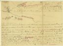
| Description: | Hand-drawn, folded extension of map, rendered on notebook paper. |
| Date: | |
|---|---|
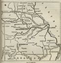
| Description: | Map of Missouri with major cities, rivers, and railroads marked. |
| Date: | |
|---|---|
| Description: | A hand-drawn map of the Boone camps on the Kentucky River. |

| Date: | 11 26 1883 |
|---|---|
| Description: | A hand-drawn map of the Clinch and Powell's Valleys, including the Cumberland Mountains, Powell's Mountains and Clinch Mountains. |

| Date: | |
|---|---|
| Description: | A hand-drawn map including the location of Daniel Boone's home and two forts, northeast of Lexington, Kentucky. |

| Date: | |
|---|---|
| Description: | A hand-drawn map of Indian boundary lines in southwest Virginia. It also includes the Duck River and the Elk River. |

| Date: | 1941 |
|---|---|
| Description: | Hand-drawn, watercolor and ink, map of Lake Mendota. Locations and many small figures appear around the shore with explanations referring to Indian legends... |

| Date: | 1860 |
|---|---|
| Description: | A hand-drawn, ink on cloth map of southeastern Wisconsin that show roads and railroads that connect Chicago to Milwaukee and other towns in the southeaster... |
| Date: | |
|---|---|
| Description: | Hand-drawn map of the town of Cadiz, Wisconsin near the Illinois border showing plots of landownership. The map also includes one landmark of the Pecatonic... |

| Date: | 1832 |
|---|---|
| Description: | A hand-drawn map showing the survey of Township number 4, Range number 5, West Fourth Principal Meridian, which is parts of the present day towns of Glen H... |

| Date: | |
|---|---|
| Description: | An ink and water color on paper, hand-drawn map showing the section divisions in the southern half of the Janesville Township (Township 3 North, Range 12 E... |

| Date: | |
|---|---|
| Description: | An ink and watercolor on tracing map showing the sections and surveyed lots in the vicinity of the Rock and Crawfish rivers in the central and eastern port... |

| Date: | |
|---|---|
| Description: | An ink and pencil on paper hand-drawn map showing sections and landowners along the north bank of the Fox River in the towns of Grand Chute and Vandenbroek... |

| Date: | 1899 |
|---|---|
| Description: | Overhead map of the Stanley McCormick's Riven Rock estate in El Montecito, Santa Barbara, California. The map shows the placement of dwellings and fields, ... |

| Date: | 1899 |
|---|---|
| Description: | A map showing the shoreline of a portion of El Montecito, Santa Barbara County, California. The map shows properties along the Pacific Ocean, and may have ... |
If you didn't find the material you searched for, our Library Reference Staff can help.
Call our reference desk at 608-264-6535 or email us at:
